While skiing for the sake of skiing is great, I'm partial to choosing trails that offer beautiful views, fun hills, cool landmarks, or even picturesque snowy bridges.
Below is a fun challenge that should motivate cross-country skiers of all abilities to get out there and discover the best trails near Calgary this winter.
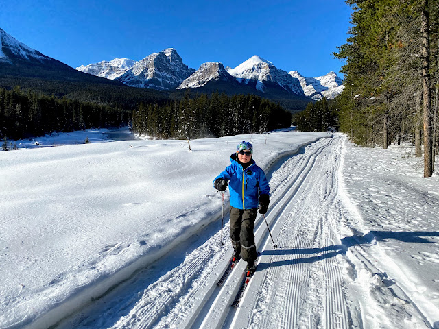
 |
| Skiing across the Spray River on the Goat Creek Trail from Canmore to Banff |
Cross-Country Ski Challenge to Discover the Best Trails around Calgary
Challenge One. Ski from Canmore to Banff
The Goat Creek Trail is an intermediate/advanced trail and it is approximately 18.5 km in length one way. Most people start on the Canmore side from the Goat Creek Trailhead where you'll lose more height than you gain (435 m lost to 160 m gained) skiing to Banff.
There are three spectacular bridges along this trail and you'll want to stop for photos at each one. If you have novice skiers in your group consider walking down to the Goat Creek Bridge. This is the crux of the trip with a sharp turn right before you reach the bridge.
 |
| Goat Creek Bridge on the Goat Creek Trail |
Most people ski this trail one direction with a car shuttle. We like to leave a vehicle at the Bow Falls parking lot in Banff because the Spray East Trail is more downhill than the Spray West Trail (and you have to finish on one of the two trails to reach Banff.)
If you don't want to set up a shuttle, strong skiers can start in Banff and ski to the Goat Creek bridge and back.
 |
| Beauty of day on the Goat Creek Trail near the Goat Creek Trailhead |
Make sure you check the recent grooming report for this trail. I've skied it when it was recently trackset (and lightning fast) and I've also skied it when it felt like we were backcountry ski touring.
You can also see a map of the trail on All Trails.
 |
| Crossing the Spray River on the Spray East Trail in Banff |
Challenge Two. Ski across the border into British Columbia
It's pretty cool when you can ski across the border into the next province and we have two trails here that allow you to do so.
There are two options here:
Skiing to the Great Divide at Lake Louise (beginner-friendly)
The Great Divide Trail starts at Lake Louise in Banff National Park and ends at the Lake O'Hara Parking lot in Yoho National Park, BC. You'll know when you cross the border at the Great Divide because you'll ski under a giant arch welcoming you to BC.
The trail is 14 km return if you ski to the arch and back. If you were to go all the way to the far parking lot, you'd be skiing 20 km return.
My son and I like to ski the trail one-way from Lake Louise to Yoho. My husband drives to the far end and skis back to meet us.
Follow this link to download a map of the winter trails in the Lake Louise area.
Check the recent grooming report for Banff and Lake Louise here.
 |
| The Alberta - British Columbia Border at the Great Divide |
Skiing to Elk Pass in Peter Lougheed Provincial Park, Kananaskis (Intermediate)
The Elk Pass Trail follows a beautiful creek and you'll end at the border of AB and BC, again with a big arch welcoming you to the Elk Valley of BC.
The trail is just under 6 km one way and climbs 200 metres. Novice skiers will find a few of the hills challenging, and you definitely need to know how to snow plow coming down. (If any of the hills are icy, it's always acceptable and safe to walk them.)
See a map of the trails in Peter Lougheed Provincial Park here.
See the grooming report for PLPP here.
For variety, we like to take the Fox Creek Trail on descent. It eliminates two of the big hills as you go around them instead of up and over.
 |
| The Alberta - British Columbia Border at Elk Pass |
Challenge Three. Ski to the top of a fire lookout
Skiers not afraid of a good climb will be rewarded with amazing views over the Kananaskis Lakes from the top of the Lookout Trail in Peter Lougheed Provincial Park, Kananaskis.
This is an intermediate/advanced ski trail with steep climbs and descents.
 |
| You won't find a better view in Kananaskis on skis |
 |
| Ski to the top of the Kananaskis fire lookout! |
To reach the site of the fire lookout (which is still active in summer months) you'll park at the Boulton Creek Parking Lot and climb up the Whisky Jack Trail. At the top turn right and continue to the junction with the Lookout Trail. The trip is approximately 12 km return and you'll gain 400 metres of height.
 |
| Looking down on the Kananaskis Lakes from the Fire Lookout Site |
See a map of the trails in Peter Lougheed Provincial Park here.
See the grooming report for PLPP here.
 |
| It's always a Winter Wonderland on the Kananaskis Lookout Trail |
Former Lookout Site: The Sunburst Trail at Ribbon Creek, below Kananaskis Village, provides access to the former Hummingbird Plume Lookout Site where you'll find the remains of a small cabin.
This is another intermediate/advanced ski trail and you'll need to be strong at climbing and descending steep hills.
Start from the Stoney (Troll Falls) Trailhead and make your way to the Skogan Pass Trail. Alternately, start from the Nakiska Ski Area where you'll find a connector trail starting from the Bronze Chair. (We park at the last overflow parking lot, north lot number four, and walk up the road towards the maintenance area to reach the bronze chair.)
 |
| Hummingbird Plume Lookout Site |
Once you're on the Skogan Pass Trail you'll climb to the junction with the Sunburst Trail. For a loop, continue to the High Level Trail and descend the Sunburst Trail after visiting the lookout site.
The shortest access to the lookout from Nakiska is approximately 4.5 km one way. You'll climb 400 metres from Ribbon Creek (less if you start from the ski hill.)
See a map of the Ribbon Creek Trails here. (You'll want the north map.)
See a grooming report for the trails here.
 |
| Views over the Kananaskis Valley from the former Hummingbird Plume Lookout site |
Challenge Four. Find a hidden snow couch
You're skiing across a snowy meadow when suddenly you spot a complete living room, made entirely out of blocks of snow! It's always a magical discovery and worth stopping for at least a snack break.
Couch Headquarters at West Elk Pass has been the most heavily visited couch site over the past couple of winters. To reach the site follow the trail to Elk Pass as described earlier in this story. Just after the junction with the Blueberry Hill Trail (before the big climb up to Elk Pass) start looking for a skier-set trail heading off to the right, down into the meadow. Follow the tracks south to a large meadow. Couch HQ is located at the beginning of the meadow (left hand side.)
Finding West Elk Pass requires easy ski touring so you'll want to wait until other users have created a trail through the meadow if you're on skinny skis. Trail breaking could be quite challenging if nobody has gone ahead of you for a month.
Note that while you are off trail here, there is no avalanche danger and West Elk Pass is safe to visit. It's a beautiful place, even if you don't find the couches.
 |
| How's this for a lunch spot! (West Elk Pass Couch HQ) |
To find out about these creations, it's best to join the Cross Country Skiing YYC group on Facebook or follow the Skier Roger website for updated trail reports.
 |
| Stopping to visit the Fork and Meadow Couch further south from West Elk Pass |
Other couches to search for:
East Elk Pass - Look for ski tracks heading south from the Tyrwhitt Trail in Peter Lougheed Provincial Park (at the bottom of the last climb up to Elk Pass.) If you follow the tracks, they will lead to East Elk Pass and a newly built snow couch.
This is considered ski touring to reach the pass but it's relatively flat and easy when somebody has broken trail ahead of you. There is no avalanche danger if you just go to the pass and back.
Fairview Loop - Somebody will usually build a beautiful snow couch in a meadow off this popular trail at Lake Louise.
 |
| Snow couch on the Fairview Loop, Lake Louise |
Follow this link to download a map of the winter trails in the Lake Louise area.
See a map of the trails in Peter Lougheed Provincial Park here.
At the time of writing most couches are located on trails for intermediate level skiers. The Pipestone Pond couch though can be accessed via a beginner-friendly ski trail.
Disclaimer: A lot of work goes into creating this masterpiece works of art. Please leave them in the same condition as you found them (or better if they need digging out and re-shaping.) Please don't let your children trample or destroy them.
It's also never a guarantee year to year that our master builders will be out creating snow furniture.
 |
| Snow couch at East Elk Pass |
Challenge Five. Ski across a frozen lake
Once lakes are well frozen, there are two that I love skiing across. Wait until January for both and check trail reports to make sure they are in condition. If they are ready to go, you'll see ski tracks across them. Both lakes have a shoreline trail as well through the trees when the lake is not frozen.
Skiing across Lake Louise (beginner-friendly)
There is an official groomed trackset ski trail that crosses Lake Louise to the far end where you'll get to see frozen Louise Falls.
From the falls you can climb up to the shoreline trail and return on that trail for a loop of 4 km. The forested trail above the lake is also groomed and trackset.
Read more about the Lake Louise Loop here.
 |
| Skiing across Lake Louise |
For more of a challenge start at the Village and climb 200 metres up the Tramline Trail to reach the lake. The trail is 4.8 km one way and follows a 3% grade. It'll feel like work going up, but it's a ton of fun coming down. (My son and I often ski down with my husband meeting us at the bottom.)
Check the recent grooming report for Banff and Lake Louise here.
 |
| Tramline Trail, Lake Louise |
Skiing across Emerald Lake to the Alluvial Fan Trail (beginner/intermediate)
This one's a little farther from Calgary for a day trip past Lake Louise into Yoho National Park, but the location is spectacular. You can either follow the forested "Horse Trail" along the shoreline of Emerald Lake, or when frozen, you can ski directly across the lake (which is what I like to do.) The Horse Trail is groomed and trackset but the lake is often skier tracked.
At the end of the lake you can ski the 4 km groomed Alluvial Fan Loop (clockwise) and then return back across the lake for an 8 km return ski. The trail is never technically difficult although there are a couple of creek crossings on snow bridges that could be interesting for a true beginner skier. (That being said, the scenery is so beautiful I encourage everybody to try this loop.)
 |
| Skiing across Emerald Lake in Yoho National Park |
I also suggest lunch at the Emerald Lake Lodge while you're here. If you're up for more of a challenge, you can also ski the Connector Trail from the Natural Bridge up to Emerald Lake. This would add on an additional 18 km round trip (unless you have two vehicles and can ski down the Connector Trail one way.) Alternately, it's a pretty trail as an out and back to the meadow after you've had lunch at the lodge.
The trails are groomed by Parks Canada. See a map of the trails here.
You can find trail grooming information here.
For information on accommodations or lunch at Emerald Lake Lodge, visit their website.
 |
| Skiing the Alluvial Fan Trail at Emerald Lake |
Challenge Six. Ski across a large snowy meadow
A meadow looks very similar to a lake when it's snow covered and these two trails below have beautiful meadows you'll want to ski across. Both are beginner-friendly and you'll want to time your visit for a sunny day.
Bill Milne Trail, Kananaskis
Start at the Kovach Pond parking lot and ski the Bill Milne Trail out and back as far as you want to go. The full trail is just under 10 km one way but the prettiest part is between Kovach Pond and the golf course. It climbs every so gradually on the way out from the pond towards Wedge Pond and then it's a fun glide back. (You won't notice the climbing, but you may notice you have less glide than normal on the ski out.)
See a map of the Ribbon Creek Trails here. (You'll want the south map.)
See a grooming report for the trails here.
 |
| Skiing across the gorgeous meadow on the Bill Milne Trail in Kananaskis |
Banff Avenue, Canmore Nordic Centre
 |
| Skiing across the meadow at the Canmore Nordic Centre on Banff Avenue |
 |
| Skiing across the meadow at the Canmore Nordic Centre |
Challenge Seven. Find a new favourite loop to ski
Most skiers generally find loops more interesting than out and back trails. They're also a great motivator because you're committed to finishing the loop if you want to get back to the parking lot. (Otherwise it can be tempting to turn around early.)
Below are some of my favourite loops:
Loop 1: Bow River Loop, Lake Louise (beginner-friendly)
The 6.6 km Bow River Loop is great for skiers of all abilities and is too beautiful to dismiss (even if you normally ski longer distances.) You'll cross two beautiful snowy bridges at the far end of the campgrounds and I love the peacefulness once you get away from the village.
 |
| Bow River Loop, Lake Louise |
The last time my family skied this loop we started at the lake and skied the Fairview Trail down to the Moraine Lake Road. From here, my husband climbed back up to the lake on Tramline, and my son and I skied down Tramline to the Station Restaurant parking lot. My husband met us at the Station where we had lunch, and then we all skied the Bow River Loop together. It made for a pleasant day of connecting trails around Lake Louise.
Check the recent grooming report for Banff and Lake Louise here.
Follow this link to download a map of the winter trails in the Lake Louise area.
 |
| Snowy day on the Bow River Loop at Lake Louise |
Loop 2: Skier Bob Special, Peter Lougheed Provincial Park (Intermediate)
This is an 18 km loop combining 5 different ski trails. Starting from the Boulton Creek parking lot you begin with a 200 metre climb up the Whisky Jack Trail. Once you get to the top things begin to improve and you're rewarded with a gorgeous ski across the Tyrwhitt Trail, one of the prettiest ski trails in the park.
You'll reach the top of Elk Pass after 8.4 km of skiing. After this, it's mostly all flat or downhill on the Elk Pass Ski Trail to the junction with Fox Creek. You finish the loop on two single track trails, Fox Creek and either Moraine or Boulton Creek.
 |
| The Tyrwhitt Trail is one of the prettiest in Peter Lougheed Provincial Park |
There are several picnic tables spread out along this loop so breaks are easy if you're feeling tired. Signage is also clear at every junction so you should never have to worry about getting lost.
See a map of the trails in Peter Lougheed Provincial Park here.
See the grooming report for PLPP here.
 |
| The top of the Elk Pass Trail on the Alberta/British Columbia border |
Loop 3: Moose Loop, West Bragg Creek (Intermediate)
For a great ski near Calgary, head out to West Bragg Creek where you'll find a large trail network. There are many popular loops here but the Moose Loop has always been one of my favourites.
The loop can be accessed via a few different trails but the shortest version is made with the Mountain Road and the Moose Connector for a 10 km outing. And it's best skied counterclockwise.
Stronger skiers can create a bigger loop with West Crystal Line - Moose Connector - Moose Loop - Mountain View West - Mountain View - West Crystal Line. This loop is approximately 14 km.
You can read about the West Bragg Creek Trails here and download a map.
See the latest trail report here.
 |
| Cross country skiing close to Calgary at West Bragg Creek |
Loop 4: Ribbon Creek - Kananaskis Village (Intermediate)
I love the Ribbon Creek Trail for the views and for the fun downhill section to the creek in all its steep twisty goodness! You'll need to be able to snowplow around steep switchback turns.
The loop that I always ski is 10 km in length and includes the following trails which you can see on the map below: Hidden - Coal Mine - Ribbon Creek - Link - Kovach - Terrace.
 |
| Viewpoint on the Ribbon Creek Trail |
This loop climbs up to Kananaskis Village if you're inclined to go inside for lunch or coffee, and then it's a fun rip back down to the creek.
See a map of the Ribbon Creek Trails here. (You'll be using the north and south maps.)
See a grooming report for the trails here.
 |
| Descending the Ribbon Creek Trail is a blast! |
 |
| Skiing along Ribbon Creek on the Link Trail |
Challenge Eight. Ski from Baker Creek to Castle Junction on the Highway 1A
 |
| Skiing along the Highway 1A in Banff |
 |
| Skiing under the cliffs of Castle Mountain along the Highway 1A in Banff |
Check the recent grooming report for Banff and Lake Louise here.
Follow this link to download a map of the winter trails in the Lake Louise area.
 |
| Skiing across a beautiful meadow between Castle Lookout and Baker Creek |
 |
| Cozy cabins at Baker Creek Mountain Resort |
 |
| Skiing the Lake Louise Loppet Course between Louise and Baker Creek |
Challenge Nine. Test your speed and skill on the Skogan Screamer
Nobody "loves" climbing the 600 metres up to the top of Skogan Pass in Kananaskis but intermediate/Advanced skiers will definitely enjoy the descent! It's as close to downhill skiing as you'll get on skinny skis and what can take 3 hours to climb up usually takes an hour at most to ski down.
Depending on which route you take (or where you start) the trip to the top of Skogan Pass is at least 17 km return but you won't really be exerting much effort on the way down, so it's more 8+ km of climbing and then an hour of snow plowing back down.
My favourite part of the trail is a 1 km long section known as the Skogan Screamer where you'll fly down a narrow twisty section of trail screaming all the way. (Hopefully happy screams.)
 |
| Skogan Pass and the end of the groomed ski trail |
Start from the Stoney (Troll Falls) Trailhead and make your way to the Skogan Pass Trail on connector trails heavily trampled from hikers heading for Troll Falls. Alternately start from the Ribbon Creek Trail and access the Skogan Pass Trail from there. Avoid the "Hidden Trail" which will take you through the Nakiska Ski Area.
Regardless of where you start, you'll reach the junction of the Hidden and Ruthie's Trails (See the map below) and the beginning of the Skogan Screamer. En route to the top of the pass you'll also pass the Sunburst Trail junction (mentioned earlier as the trail you'd take to reach the Hummingbird Plume lookout.)
After the junctions with the Sunburst and High Level Trails, you have another option: go straight for Skogan Pass, or take the Skogan Loop (a longer, much hillier trail.) I never have the energy to take the loop and just go straight on the Skogan Pass Trail. It's usually all I can do just to make it to the top of the pass.
See a map of the Ribbon Creek Trails here. (You'll want the north map.)
See a grooming report for the trails here.
 |
| My son first skied the Skogan Pass Tail at age 9 |
Challenge Ten. Pick a "big for you" distance, height, or difficulty challenge
I was obsessed with trying to reach 30 km last winter and it became my personal goal. I have another friend working her way up to 15 km (and it's her first winter on cross-country skis.) Some of you are intrigued by a certain trail and are determined to check it off your list this winter.
Whatever the goal, pick a challenge that's right for you and set out to make it happen this winter.
Need inspiration? Make sure you've joined the Cross-Country Skiing YYC Facebook group.
 |
| Pick a challenge and get out there this winter! (Photo: Blueberry Hill, Peter Lougheed Provincial Park) |
Additional Resources
The Best Beginner Cross-Country Ski Trails near Calgary
Family Cross-country Ski Trips - Our Favourite Destinations near Calgary
Cross-Country Skiing at Lake Louise: Where to Ski and Stay this Winter
Bed and Breakfast Cross-Country Ski Getaway at Lake Louise


