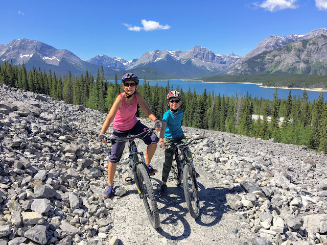
We can officially say that we have a favourite bike trail in Alberta, and we believe it is the most beautiful trail for mountain biking in all of Southern Alberta. It's also a lot of fun, and there was a lot of whooping and hollering going on in our party on the flowy descents.
 |
| Biking on the High Rockies Trail in Kananaskis |
Introduction to the High Rockies Trail in Kananaskis
The High Rockies Trail is a newly completed 80 km long multi-use trail outside of Canmore, Alberta. The trail starts at the popular Goat Creek Parking Lot on the Smith-Dorrien/Spray Lakes Trail and ends on the Alberta/BC border at Elk Pass in Peter Lougheed Provincial Park, paralleling the Spray Lakes Road until you reach the Lower Kananaskis Lake.
 |
Views along the trail are spectacular!!
|
The trail travels through through three provincial parks, Bow Valley Wildland PP, Spray Valley PP, and Peter Lougheed PP with numerous day use areas and campgrounds along the way.
While much of the trail truly excels as a mountain bike trail, it is also becoming popular with hikers, and is even enjoyable in winter on snowshoes, fat bikes, or cross-country skis. And there's one section that's even paved for super easy riding!
Visit the
Kananaskis Trails website to see detailed maps for each section of the trail. I have the maps downloaded on my phone to access without cell coverage.
 |
| Much of the trail is easy riding like this |
I'll be updating this guide annually, and for now, I'm writing about the sections of the High Rockies Trail that we've actually ridden so far. I'll also be focusing on biking the trail (even though you can also hike it.)
 |
| Fun flowy mountain biking on the High Rockies Trail |
Three Sisters Dam to Goat Creek via Goat Pond
Distance: 10.5 km one way, double track, Chariot-friendly
Height gain/loss: 207 metres climbing, 263 metres descent (riding towards Goat Creek)
Kananaskis Trails Map: North High Rockies Trail Map
Trail Forks Map: High Rockies Trail (Trail Forks has the route broken down into 10 segments.)
Parking: There is a parking area beside the dam along the highway (before you cross the dam to the Spray West Campground.)
 |
Goat Pond is a great rest stop along the way
|
Highlights: A long boardwalk and several bridges near Goat Pond. Goat Pond is also a fun rest stop.
Description: This section is great for an easy family mountain bike ride. The trail is double track the entire time and follows old roads. If you can set up a vehicle shuttle, start at the campground and ride down to Goat Creek. Often, we send an adult back for the vehicle at the halfway mark if we only have one car.
Ridden towards Goat Creek this section of trail is a LOT of fun and there are several long descents where you'll be flying, screaming at the top of your lungs to alert bears to your presence. The trail is not technical but children should have experience riding off pavement. Gears would be very helpful and expect to walk some sections if kids do not have gears.
Bring the bear spray because this is a remote section of trail and there's often bear scat along the side of the trail.
 |
| Riding across the long boardwalk near Goat Pond |
Shorter Outing: For a shorter ride, start at the campground and make your way to Goat Pond and back for an easy 7.6 km return trip (no shuttle needed.) The reward for this section is the boardwalk and bridges over the many creeks near the pond.
Options for Hiking: This would be a pleasant hike out and back from the Spray Lakes West Campground. Kids would enjoy the bridges and boardwalk around Goat Pond.
Camping: First come first serve campsites can be found at the
Spray Lakes West Campground.
Alberta Parks has also "installed a number of Hike/Bike only campsites down the Spray valley associated with long distance use of the High Rockies and Great Divide trails. These are located at Spray West Campground, Buller Pond and Sawmill. Use is restricted to non-motorized travelers." - Friends of Kananaskis
 |
There are many fun bridges to cross on this section of trail
|
 |
Easy riding between the Three Sisters Dam and Goat Creek
|
Driftwood to Three Sisters Dam
Distance: 3.3 km one way, easy intro singletrack terrain
Height gain/loss: 12 metres climbing, 20 metres descent (ridden towards the Three Sisters Dam)
Parking: Park at the Driftwood Day Use Area
 |
Easy singletrack riding along the Spray Lakes Reservoir
|
Highlights: This is a great extension to the Three Sisters Dam to Goat Creek ride. We usually start at Driftwood and end at Goat Creek so that we get a little bit of singletrack riding at the beginning of our trip.
It's also very pretty riding along the lakeshore of the Spray Lakes Reservoir and Driftwood is a great picnic area with several picnic tables located along the lakeshore.
Description: Easy intro-singletrack riding for novice riders. The trail is narrow with little ups and downs. There are a few rocky sections and a few fun flowy parts. The trail rides well in both directions if you want to do an out and back for a short ride.
Options for hiking: This would be a very pretty trail to hike if you were camping at the Spray Lakes West Campground.
Camping: First come first serve campsites can be found at the Spray Lakes West Campground.
Alberta Parks has also "installed a number of Hike/Bike only campsites down the Spray valley associated with long distance use of the High Rockies and Great Divide trails. These are located at Spray West Campground, Buller Pond and Sawmill. Use is restricted to non-motorized travelers." - Friends of Kananaskis
 |
A good example of this section of trail between Driftwood and the dam
|
Buller Day Use Area to Spray Lakes Day Use Area
Distance: 7.5 km one way, rolling intermediate terrain.
Height gain/loss: I don't have an exact number here but the trail has some steep climbs and equally long descents. Expect to be climbing 300 - 400 metres if you go all the way to the Spray Lakes Day Use Area. (Closer to 200 metres if you only go as far as the end of the avalanche slopes.)
Parking: Buller Day Use Area
Highlights: Gorgeous views down to the Spray Lakes Reservoir from rocky avalanche slopes
 |
| Crossing avalanche slopes on the High Rockies Trail north of the Buller Pass Trail |
Description: This is the most beautiful section of the entire High Rockies Trail as you travel high up above the Spray Lakes Road looking down on the lake below. It is a challenging mountain bike ride (best enjoyed with older youth or teens who have some solid mountain bike skills.)
To bike this section, you’ll have to first climb up 900 metres of the Buller Pass Hiking Trail (44 metres height gain.) Turn left onto the High Rockies Trail when you see it coming in from the north. From here, you’ll travel through a summer-only section of the trail for 4.7 km (where the best views can be found.) Continue to the Spray Lakes Day Use Area (where you’ll want a second car parked) or turn around at any point if doing an out and back trip.
 |
| How's this for a bike trail?! |
Shorter Recommended Outing: When my family rode this section, we exited the trail at the end of the 4.7 km mark where you can easily drop down to the highway. From here, my husband biked back for the vehicle (though you could bike back on the road as well.)
If you go past the avalanche slope section at the end of the 4.7 km mark, know that you will be climbing back up to your previous high point before the trail dropped down to the highway. (The trail drops down to the highway after the rocky slopes shown in these photos and then climbs back up!)
Personally with kids, I'd just exit when you reach the highway rather than doing the additional climb. If you choose to keep going, the trail doesn't actually go down to the Spray Lakes Day Use Area so you'll have to push your bikes down a short access trail.
Options for Hiking: Families may enjoy hiking this part of the trail for the views. Just make sure you watch out for mountain bikers coming up behind you on descents and step off to the side of the trail to let them pass.
Consider an out and back trip to the first rocky avalanche slope. The second one is higher, but you’ll still get amazing views from the first viewpoint in a round trip distance of less than 8 km (including the distance on the Buller Pass Trail.)
 |
| Biking across rocky avalanche slopes |
Camping: You can either camp at the Spray Lakes West Campground or you can camp at one of the
campgrounds in Peter Lougheed Provincial Park (where you can also make reservations.) A couple of the campgrounds in PLPP also have power hookups for trailers (and some sites have water as well.)
Alberta Parks has also "installed a number of Hike/Bike only campsites down the Spray valley associated with long distance use of the High Rockies and Great Divide trails. These are located at Spray West Campground, Buller Pond and Sawmill. Use is restricted to non-motorized travelers." - Friends of Kananaskis
 |
| The high point on the High Rockies Trail north of the Buller Pass Trailhead |
Spencer Creek to Spurling Creek
Distance: 4.5 km one way
Height gain/loss: I don't have an exact number here but you'll start your ride with at least 45 minutes of climbing before you get to earn your fun descent. The good news is that you lose much more than you gain riding towards Spurling Creek (and the descent really is worth the climbing.)
Kananaskis Trails Map: North High Rockies Trail Map
Trail Forks Map: Buller to Driftwood (you'll be doing a section in the middle)
Parking: Park at Spencer Creek which is the trailhead for the Little Lougheed Hiking Trail. You can
find it on All Trails here. You'll end your ride at the
West Wind Pass Trailhead where you'll need a second vehicle. Alternately, park your second car at the Driftwood Day Use Area which is close by.
Highlights: You'll have to earn your downhill fun on this section, and you'll climb for the first 3 kilometres (gaining at least 100 metres of height.) After that though it's 1.5 km of glorious downhill that the family will love.
 |
| Riding between Spencer and Spurling Creek on the High Rockies Trail |
Description: Park beside Spencer Creek on the highway and from here, it's a short 350 metre hike-a-bike up the creek (and that's distance, not height, so it will only take you 20 minutes.) There's a good trail on the left hand side of the creek.
Alternately if you don't want to start at Spencer Creek, you can start at the Sparrowhawk Day Use Area, but there's a LOT of climbing if you start here and the High Rockies Trail is 750 metres above the highway at this point so it's a very long hike-a-bike if you choose this starting option.
 |
| Hiking bikes up the Spencer Creek Trail |
Once you come to the High Rockies Trail from Spencer Creek, turn left and ride towards Spurling Creek where you'll drop down to the highway for an easy exit. This is also the West Wind Pass Trailhead so you'll see many cars parked along the side of the road here.
 |
| A scenic section of the High Rockies Trail between Spencer and Spurling Creeks |
Note you'll have to either shuttle this section or send an adult back for your vehicle at Spencer Creek. If you are sending somebody back, continue on down the road to the Driftwood Day Use Area (either on the High Rockies Trail or just on the road - it's a very short ride on the highway) and enjoy a picnic beside the lake.
My husband picked us up at Driftwood and it was a short 5 minute ride on the highway from the Spurling Creek Trailhead.
2020 update: I have since ridden the section from Spurling Creek to Driftwood on the High Rockies and trust me, with kids, you want to take the highway! It's a difference between 5 minutes on the highway to 45 minutes on the trail pushing your bike up big climbs over very rocky terrain.
 |
| Driftwood Day use area - a great spot to wait while somebody rides back for the vehicle |
Rummel Trailhead to Buller Day Use Area
Distance: 8 km one way including a 2 km section on the Rummel Trail to join the High Rockies Trail
Parking: Park at the trailhead for Rummel Lake on the highway just beside the turnoff for Mount Engadine Lodge. (See the Rummel Lake Connector Trail above for map.) And you'll be ending at Buller Mountain Day Use Area.
Highlights: Scenery! You'll have to work for it though with an initial 200 metre climb up the Rummel Trail to a scenic bench. You'll continue to climb after that for another 162 metres, but then it's glorious downhill (some of my favourite on the High Rockies Trail) with a fun flowy descent of 383 metres.
 |
| Scenic bench at the top of the Rummel connector trail |
Description: We haven't done this section as a family yet but I rode it with a girlfriend and I think it has potential for a fun family ride (for older children, teens, and strong riders.)
We parked at the Buller Pond day use area so that we'd have a vehicle at the end after riding down the Buller Trail. We then climbed up the road for about 20 minutes, gaining height most of the time until we reached the Rummel trailhead.
 |
| The section between Rummel and Buller has many pretty viewpoints |
We rode (and did a lot of walking) up the Rummel Trail but it only took one hour total (highway + trail) until we were at the top which wasn't too bad. At the top you are rewarded with amazing scenery, a beautiful bench for a lunch break, and options for fun.
We did a short 5 km out and back ride towards the Chester Trailhead (climbing most of the way out and then enjoying a fun ride back to the bench.)
 |
| High Rockies Trail near the Rummel bench |
Back at the bench we had lunch and then started making our way down the trail towards the Buller Trailhead. There was a lot of climbing for the first 3 kilometres (several dips down and back up for creek crossings) but then there was a glorious descent for the final 3 kilometres and it was a TON of fun!
What I loved most about the long descent was that it was never overly steep or technical. I never had that feeling that I was already braking as hard as I could - and was still going too fast. It was just a long pleasurable descent and extremely flowy.
 |
| Bench at the top of the Rummel Connector Trail |
Blackshale Creek to Peninsula Day Use Area
Distance: 3.8 km one way, mostly all downhill
Parking: Park on the side of the road for the
Blackshale Suspension Bridge. There are trails that go up both sides of the creek and it doesn't matter which one you choose. If you choose the leftmost trail though you will be forced to cross the suspension bridge. So if you have a fear of heights, pick the right side trail.
Highlights: The 240-foot-long suspension bridge will be the highlight of this section for your family. For many, it will be the highlight of the entire trail.
 |
| Biking across the suspension bridge above Blackshale Creek |
Description: Climb up roughly 500 metres in distance (gaining approximately 50 metres of height) to reach the bridge. And it doesn't matter if you have to push your bike the entire way up - the descent is worth it!
We climbed up to the bridge and the kids happily crossed the bridge back and forth dozens of time! (It felt as if we’d hiked up to a hanging playground.)
 |
| The highlight of the High Rockies Trail for families |
From the bridge, continue in a fun downhill ride to the Peninsula Day Use Area where you’ll want a second vehicle parked. Alternately if you don’t have a shuttle, an adult can bike back for the car while you hang out beside the Lower Kananaskis Lake at the Peninsula Day Use Area (a great spot for cooling off if it’s been a hot day.)
For families wanting to bike this section, it is a very fun, fast, flowy descent down to Peninsula. Children will need some solid experience with mountain biking but can always walk any hill that looks to be too steep. The trail is very smooth, and we had a lot of fun riding it.
 |
| The trail down to Peninsula was very fast, flowy, and fun!! |
Shorter Outing for Hikers: If you just want to hike up to see the bridge, consider walking up to the bridge on one side of Blackshale Creek, crossing the bridge, and descending on the other side of the creek. There are good trails on both sides of the bridge leading down to the highway. Round trip distance is a kilometre.
Camping: Choose one of the
campgrounds in Peter Lougheed Provincial Park. There are options for reserved camping, first come first serve camping, and there's even a tents-only campground.
 |
| Great views from every section of the High Rockies Trail |
Boulton Creek to Canyon
Distance: 8.5 km on a paved rolling bike trail. Chariot-friendly
Parking: Park by the Boulton Creek Trading Post
Highlights: A paved trail that is great for families with strollers, bike trailers, or chariots.
 |
| Paved biking on the High Rockies Trail through Peter Lougheed Provincial Park |
Description: This section of the trail takes you from the Canyon Campground to the Boulton Creek Campground in Peter Lougheed Provincial Park. The entire distance is paved and great for a family bike ride. (and if the Boulton Creek Trading Post is open you can buy ice-cream at the end.)
While you can ride this trail in either distance, we prefer riding it from Boulton Creek to Canyon where it feels more downhill.
A vehicle shuttle can easily be set up for one-way riding if traveling with friends. Otherwise, we like to end at Canyon by the campground playground while an adult rides back for the car.
Shorter Outing: Ride between the Canyon and Elkwood Campgrounds for a shorter 3.7 km distance one way (ideal if riding both directions without a shuttle.) The Elkwood-Boulton Creek section can also be ridden in 4.8 km (one way.)
Camping: Again, choose one of the many campgrounds in Peter Lougheed Provincial Park. We like camping at Boulton Creek so we can bike right out of our campsite. Alternately, camping at Canyon is nice too so an adult can return for the vehicle while you hang out at your campsite.
Note: this section of the trail is periodically closed due to active bears in the area so always check the
Alberta Parks Trail Report before heading out.
 |
| Family biking on the High Rockies Trail between Boulton Creek and Canyon |
Safety Tips for Biking on the High Rockies Trail
- Each member of your family should have a mountain bike (recently tuned and in good working condition) for this trail. Suspension isn't vital for the kids, (adults may appreciate having a hard tail with front suspension,) but I do recommend the kids have hand brakes.
- There are no services or facilities along much of the trail. Take a bike repair kit, spare tubes, a first aid kit, water, layers of clothing, and sufficient food/snacks for your outing.
- If you will only be riding your section one-way, plan the return to your vehicle in advance for maximum safety. We neglected to think about this and ended up with my husband riding back solo at one point, my son and I left with no water, no backpack, no bear spray, and no food. It wasn't our finest moment in backcountry responsibility. In hindsight, each adult should have had a backpack with their own provisions for the end of the ride.
- Pick up a map at the Barrier Lake Visitor Information Centre or download the section you want to ride from the Kananaskis Trails Website.
- Make lots of noise to alert animals of your presence and take bear spray with you. It’s also a good idea to travel in a group.
- Take rest breaks well off to the side of the trail, removing your bike safely to the side as well. I also recommend listening for fast riders coming up behind you. It would be a good idea to move off to the side to let them pass.
- Visit the Kananaskis Trails website for more information on each section of the trail along with detailed maps.
 |
| There is no shortage of bridges on the trail |
The trail can also be found on the
Trail Forks website or app, where you’ll find the height gain for each section. Know though that the trail is broken down into different segments on Trail Forks. The link above going to the longest segment.
 |
| A spectacular bike trail in Kananaskis |


