Everybody needs a happy place and for us, it's the Columbia Valley stretching from Radium Hot Springs to Fairmont Hot Springs. From there we head further south to Kimberley, or north to Golden.
Located across the border in British Columbia, the Towns of Radium Hot Springs and Golden are only 3 hours from Calgary by car and very accessible for a weekend getaway. Add an extra half hour from Radium, and you are at Fairmont Hot Springs. Take it further for a long weekend and you can also reach Kimberley to the south.
 |
| Awesome family mountain biking in the Columbia Valley, BC (Deja View Trail) |
This story receives annual updates, additions of new trails, and photo upgrades. If you have any questions about the trails please send me a message by email (check my "contact me" page.)
Trails around Radium Hot Springs and Area
The Radium Hot Springs Bike Park and Sinclair Creek Trail
The
Radium Pump and Jump is located in Sinclair Creek. You can either just walk/bike down off of Forsters Landing Road or you can drive to the official parking lot and bike along the creek to reach the bike park (and the link above gives directions for both options.)
 |
| Playing at the Radium Pump and Jump |
We love biking along the
Sinclair Creek Trail on our way to/from the bike park. It is a lovely gravel hiking trail, only 1.2 km long (one way,) double track width the whole time, and pretty much flat the entire distance. It's a great trail for novice riders.
 |
| Radium Pump and Jump Bike Park |
The pump track is a great addition to the town, and combined with a bike ride or hike along Sinclair Creek, makes for a great half day adventure. (and even adults will have fun playing in the bike park.)
 |
| Easy biking along Sinclair Creek, Radium Hot Springs |
Family Biking at Nipika Mountain Resort, near Radium Hot Springs
Spend a weekend or a day at Nipika Mountain Resort just outside Radium Hot Springs and you can bike on 100+ km of singletrack and double track bike and ski trails. We spent a weekend here in May of 2015 and loved it! Our group of kids biked about 15 km over our two days spent here and had a lot of fun exploring the Natural Bridge and the Canyon Bridge.
For more information and a full trip report, please read my story on our experience:
Kids on Wheels - Nipika Mountain Resort.
 |
| Family Riding at Nipika Mountain Resort |
Suggested Bike Loops at Nipika Mountain Resort
First, visit the Trail Forks site to see a
map of the Nipika bike trails so you can get a general idea of where I'm sending you on the following suggested loops. All loops below follow the north trails.
Double track easy loop: Starting from the day lodge, follow "Main Street" to the meadow where you'll find a warming hut and outhouse bathroom. Follow the cross country ski trails from here to the Natural Bridge (there are maps at the day lodge if you want to take one with you, and you'll find a map at every trail intersection as well.)
Cross the natural bridge and continue following the cross country ski trails around until you come to the Canyon Bridge. Cross, and make your way back to the day lodge for a loop that's approximately 10 km in length. Read the full trip report for this loop here:
Kids on Wheels - Nipika Mountain Resort
And if you read the story above, I've offered suggestions on how to add some easy singletrack biking to the loop.
 |
| Crossing the Natural Bridge on the cross country ski trails |
Singletrack easy/intermediate loop: Follow "Main Street" from the day lodge to the first meadow with the warming hut. From Main Street, you can do an optional short out and back ride on "Teen Spirit" to get an idea of what Nipika singletrack looks like. It's only 600 metres long one way and is a fun flowy trail (especially coming back down towards the meadow)
Back at the meadow, follow Dunbar's Trail (easy, flowy, and fun) to the intersection with Cliff Hanger. You'll follow CH for a short distance until you get on the Kootenay River Trail. The river trail is 1.8 km long and relatively flat. It is quite rooty in spots, but it's nothing that a 20" bike can't handle. There's one challenging hill you'll have to push your bikes up, but other than that, it's easy riding and it connects several small beach areas to stop and play at.
 |
| Beach area along the Kootenay River Trail |
Once you reach the last beach area on the Kootenay River Trail, you'll have to push your bikes up a steep hill (a double track ski trail) to get back towards Main Street. From here you can either follow ski trails back to the day lodge (or be adventurous like us and attempt to bike Chamois Whammy.) Note that Chamois Whammy is very exposed in spots and that a fall could end in the river far below you. My son wasn't scared at all when we just did this in 2017 (age 8) but I walked a lot of it.
This loop is no more than 7 to 8 km in total distance.
Recommended for competent riders with previous mountain biking experience on bikes with at least 20" tires, hand brakes, and gears.
 |
A look at some of the narrow riding along Chamois Whammy at Nipika Mountain Resort
|
Biking the Old Coach Trail from Dry Gulch to Radium Hot Springs
The Old Coach Trail, an old historic road, is one of the nicest family-friendly mountain bike rides in the valley and isn't too long if you set up a vehicle shuttle or send an adult back for the car. The Old Coach Trail is double track the entire time and is 9 km one way.
There's a lovely coffee shop on main street as well near the end of the trail in Radium Hot Springs if you should find yourself waiting around with the kids while another adult is riding back to the trailhead for the vehicle. There's also an ice-cream shop on main street on the other side of the highway.
 |
| Biking the Old Coach Trail from Dry Gulch to Radium Hot Springs |
We first biked the trail with our son at age 4 and while challenging at that age, he did awesome. My husband ran along beside him to offer a bit of assistance on the occasional steep hill or loose gravel patch but by age 5 he was doing fine - and just walked the big hills (of which there are a few.)
Route Directions:
We prefer to start at Dry Gulch, biking into Radium Hot Springs. This way, most of the ride is gradual downhill until the final climb back up to town at the end. Note that the final hill is over 2 kilometres long in distance (and quite steep) so bring lots of candy for the end.
 |
| Climbing up the final section of the Old Coach Trail to Radium Hot Springs |
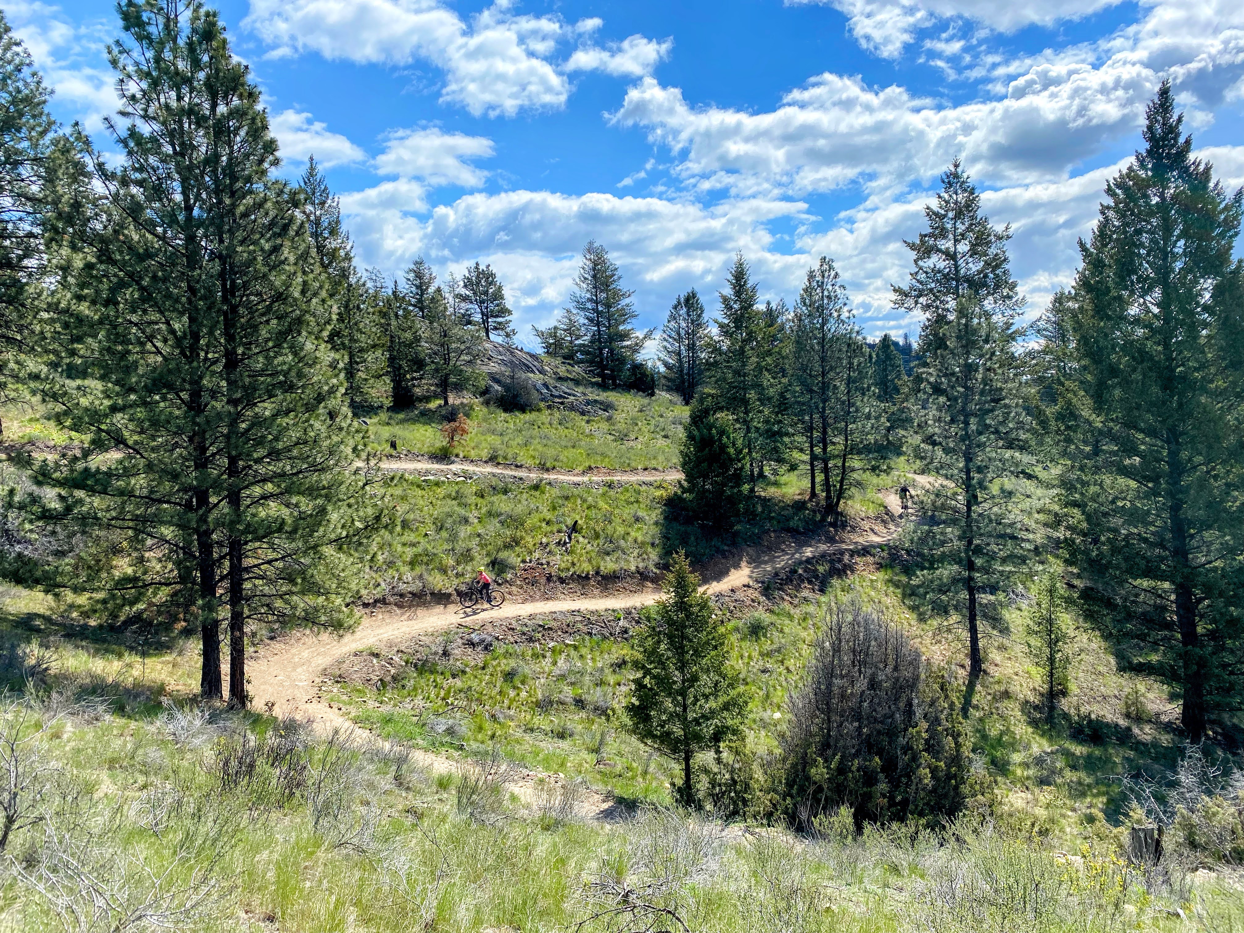
Deja View (Singletrack Extension to the Old Coach Trail)
This is one of our favourite mountain bike trails in all of the Columbia Valley. It's smooth, flowy, technically easy, and there are very few roots or rocks. It's paradise!
From the Old Coach Trail, there are fun singletrack trails off the river side of the gravel road.
The singletrack trails on the river side of the Old Coach Trail are collectively referred to as the Deja View Trail and we've ridden all 5 of the loops on the river side. The first and second loops closest to Dry Gulch are especially good for novice mountain bikers, and then each loop gets progressively harder.
 |
| Easy singletrack riding on Deja View off the Old Coach Trail |
This trail was recently removed from Trail Forks because it is not a sanctioned trail. You can still ride it, but unfortunately I can't give you a nice link for more information. You can however see
Deja View and the Old Coach Trail on All Trails.
Below are my best directions for accessing the singletrack loops off the Old Coach Road:
First, go through the gate at the far left side of the parking lot. Follow the gravel road (the Old Coach Trail) until you come to a singletrack trail to your left (on the river side of you.)
This is the beginning of the first loop on Deja View. Ride this loop clockwise for best flow. When you get to the end, either return to the parking lot on the Old Coach Trail or keep going along gravel road until you come to the second loop. There are 5 in total.
Ride as many as you want and then either return to the parking lot on the Old Coach Trail, or finish your ride on the OCT, ending in Radium.
If you were to just ride the first loop and return on the Old Coach Trail, your total distance would be less than 5 km.
 |
| Amazing views on the Deja View Trail |
The beauty of the mountain bike loops along Deja View is that you can ride as many as you want for a short out and back ride. Start at Dry Gulch, ride a few loops, and come back on the old road. (It will be a gradual uphill climb the whole way back on the Old Coach Trail so save energy for the return ride!!)
Alternately, ride some of the loops and then continue on the Old Coach Trail to the far trailhead in Radium Hot Springs so that you don't have to backtrack at all. This is what we usually do. (And my husband always rides back for the truck.)
 |
| Flowy easy riding on Deja View |
And my best suggestion for "what age do you recommend this trail for?" - Try the first loop. If it's way too hard, stick to the Old Coach Trail. If it goes well, try the second loop. Walk any hills that scare the kids and push your bike up any hills that are too steep. The beauty of this trail is that the hills are never that long and it's a very cruisy, flowy, cross country ride.
 |
| Our favourite bike trail in the Columbia Valley |
Trails around Invermere and Area
Lillian Lake Trails, near Invermere
 |
| 5 year old approved! |
If you go to the
Trail Forks website you'll find a map showing the amazing bike trails at Lillian Lake near Invermere. The
"Junior Johnson" is a double track trail, great for families and beginner riders. It has a couple of steep hills but there are mild elevation changes along most of the trail. And it's very short (a 3 km loop) so you'll only be riding it for an hour or two at most!
Our 5 year old still found the trail to be a challenge when we first rode it but it's one of the easiest trails in the area by far!
 |
| The Junior Johnson: Balance bike friendly |
The trail would be chariot-friendly too. Just don't take
babies that you don't want to be jostled around a bit because it is
bumpy in spots.
Once you've mastered the Junior Johnston, the next trails to try are
"Let it Flow" and
"Filler up." They are rated "green" but are singletrack and quite a bit more difficult than the Junior Johnson. There are quite a few hills as well and you definitely need gears on the kids' bikes.
Note if you're going to ride "Let it Flow" and "Filler up,"
check Trail Forks to ensure you're going the right direction. "Filler up" is the climbing trail and "Let it Flow" is the descent trail for the loop. Depending on where you join up with this loop you'll either climb first or descend first.
Once you've mastered all of these trails, you can try sections of "
the Johnson" or the "
Kloosifier." My husband and son also really love the "
Arch Potential Trail," which has a crazy snake-like section in the middle where you wind up and down a gully. (note it is a downhill trail and you need to start from the Johnson parking lot in order to get the best flow on the snake part.)
 |
| The Junior Johnson double track trail |
Arch Potential - Johnson Intermediate Loop (Lillian Lake)
A great intermediate loop can be made of approximately 8 km, allowing families to try a bunch of trails in the Johnson area without committing to any of the longer ones. This is also a great way of testing to see if the kids are ready for either the Johnson or the Kloosifier Trails.
From the Johnson Parking lot follow the
Arch Potential Trail up and down to a junction with the Johnson Trail. Arch Potential has a lot of climbing along with some steep descents. There's also a snake section in the middle where you wind up and down two sides of a gully (which my boys loved!!)
From the end of Arch Potential, turn left onto the
Johnson Trail (east along the river bank) heading for the junction with
Let it Flow (a green single track trail.) You'll only be on this trail for a short distance until you come to a connector trail leading to the junction with
Filler Up.
 |
| Arch Potential Trail near the junction with the Johnson |
Climb "Filler Up" and then descent on "Let it Flow." (It's a loop, but you have to ride it the correct direction.) At the bottom of "Let it Flow," hop on the short connector again until you return to your previous junction with "Filler Up." This time, take the Johnson Trail back to the parking lot.
Note, most people ride this section of the Johnson Trail in the opposite direction when doing the full loop so pay attention to bikers coming towards you and perhaps hop off the trail since you're going against the flow. It's the only way to get back to the parking lot though.
And in case you're wondering what this loop would be like in reverse, Arch Potential is a downhill specific trail and the snake section does not work in the opposite direction. You need to start on Arch Potential from the Johnson parking lot.
In case I totally lost you, refer to the Trail Forks website or app (I highly recommend putting the app on your phone because it's easier to see where the high and low points are for choosing which direction to ride a trail.)
 |
| Easy flowy section on "Let it Flow" |
The Kloosifier Trail (Lillian Lake)
The
Kloosifier Trail is one of our new fav. trails in the Columbia Valley, but my son didn't graduate to this trail until he'd ridden all of the other intermediate cross-country trails in this guide! He finally rode this loop at age 10 (and we still walked a lot of hills, both my son and I.) - heck, I still do!
The full loop is 8.2 km and the trail is amazingly flowy, smooth, and fun. Expect very few roots or rocks, but a few sandy sections if it hasn't rained recently. The trail is much more technical than others like Deja View outside Radium Hot Springs or the Spirit Trail in the Fairmont area - both which you should ride FIRST.
 |
| Scenic riding on the Kloosifier Trail, Lillian Lake, Invermere |
My suggestion is to start with other intermediate trails in the valley and work your way up to this one with the kids. It's also not a bad idea to solo ride it first as an adult. I'm not ashamed to admit that I have to walk some sections because a few of the hills scare me.
This trail is very beautiful though and I highly recommend it for the views alone.
 |
| Biking along the top of the hoodoos on the Kloosifier |
 |
| Flowy fun riding on the Kloosifier Trail, Lillian Lake |
The Johnson (Lillian Lake)
You've ridden ALL of the intermediate trails at Lillian Lake, you've ridden the Johnson as an adult (without the kids,) and you're confident they can ride it. Proceed.
The Johnson is another great loop with great flow but is considerably more technical than the Kloosifier. There's also some serious exposure along the cliffs above the river (where a fall would result in serious injury.) The full loop is 10 km, but can be shortened if you don't want to ride the back loop where the exposure is the worst. There is still significant exposure on the main loop though so it can't be completely avoided even if you shorten the loop. (And there are no ride arounds. It's ride or walk these sections.)
My son started riding this loop at age 11 after riding all of the other trails at Lillian Lake. The trail was rated intermediate but a few accidents later, and it's been upgraded to advanced. The loop is ridden clockwise.
 |
| Looking out over the hoodoos on the Johnson Trail |
Rock'n the Flume (Lillian Lake)
My boys rode
Rock'n the Flume last summer when my son was 11, and loved the interesting rock slabs and features. If you've got excellent riders, give it a try. The loop is short at 2 km in distance and features can be walked or ridden around. This is an advanced trail and is rated as such. Expect stiff climbing and rock slabs throughout.
 |
| Wooden features on Rock'n the Flume |
Panorama Mountain Resort Trails, near Invermere
Panorama has options for cross-country biking (which is free and very family-friendly) and for downhill resort biking where you pay to ride the chairlift with your bike.
XC Option One: The Paved Valley Trail Loop
The first option here is the
Valley Trail, a paved 3.9 km loop. And while it is paved, know that there is some steep climbing from the upper village to the Grey Wolf golf course. Once you leave the golf course, you'll be riding down to the lower village (where you'll have one section of very steep switchbacks.)
The best direction to do this loop is from the Upper Village up to the golf course and then down to the Lower Village. You'll end up at the gondola (which you can ride for free with your bikes back up to the Upper Village.)
I do not recommend riding uphill from the Lower Village to reach the golf course. This would involve biking up the steep switchbacks.
 |
| Riding the paved Valley Trail at Panorama Mountain Resort |
 |
| The first cabin on the Pacer Trail |
XC Option Two: Hale Hut Ride
For a second option that is more of an easy mountain bike ride (and not paved) you can bike from the Grey Wolf golf course up to the Hale Hut in roughly a 5 km return ride. You'll be riding on winter ski trails.
You'll start on the
Pacer Trail, a double track gravel trail, and you'll pass by a small cabin before reaching the junction with the
Hale Trail.
The Pacer Trail gains about 100 metres but it is never overly steep. You can always push your bike up any hill that proves to be too difficult. From the junction with the Hale Trail you'll gain another 60 metres or so (in a very short distance.) We pushed our bikes up most of this section (which thank goodness only took about 10 minutes at the most.)
The ride out from the Hale Hut is very fast and you'll be at the final climb back up to the golf course in no time!
 |
| Hale Hut (which is open for warming up in on cool days) |
XC Option Three: Combine the Valley Trail and the Hale Hut Trip
Starting at the Upper Village, bike the Valley Trail until you reach the golf course. Hop onto the Pacer Trail and ride out to the Hale Hut. Return and then finish your ride on the Valley Trail, heading down to the Lower Village. Ride the gondola back up to return to your starting point at the Upper Village.
Total distance here would be roughly 9 km. It is a half day outing and fun for families staying in one of the condos at the resort.
You can see
all of the trails at Panorama Mountain Resort on the Trail Forks website.
 |
| Riding along the Pacer Trail en route to the Hale Hut |
Lift-accessed Bike Park at Panorama Mountain Resort
My boys finally gave this a whirl in summer 2024 and they had a blast. For a reasonable fee you can access the Mile One chairlift all day for lift accessed mountain bike trails that are flowy, full of jumps and berms, and high on technical features should you choose the more advanced trails.
It's recommended that you start with the freeride trails which are machine built flow trails containing man-made features including berms, jumps, table tops, and wall rides. The order of progression should be "Let it Ride" to "Rocking Horse" (both green beginner trails) to "Sanchez" and "Mercy Me Jumps" (blue intermediate trails.)
 |
| Unless you're a bike park pro, this will be your first trail down the mountain |
If you LOVE "Mercy Me Jumps", as my boys did, then move on to "Hell's Bells." It's a black flow trail with gigantic jumps. My 15 year old thought it was a blast!
Panorama also has technical trails which contain natural features such as rocks, roots, drops, and logs along with freeride features. My suggestion here is to start with "Mercy Me" which will take you into "Mercy Me Jumps."
If you love the technical features on "Mercy Me," move on to "Stiffy" which is easier than "Bazooka Joe." These are all blue intermediate trails. There are no beginner technical trails.
 |
| Full face helmets and padding are highly recommended! |
And, keep in mind that "beginner" doesn't necessarily mean true "beginner!" This is beginner downhill biking, not beginner biking period. Start the kids out on "Let it Ride" and "Rocking Horse" even if they roll their eyes at you.
 |
| Sure beats climbing the mountain a bunch of times! |
Toby Creek Adventures Bike Park
Toby Creek Adventures also has an awesome downhill mountain bike park and it's right across the road from Panorama Mountain Resort! It's perfect for families staying at or near Panorama wanting an extra half day of riding.
We just visited it in August, 2025, and to say that this downhill bike park is "awesome" would be an understatement. In my husband's words: "It's one of the best intermediate flow trails I've ever ridden. It was very smooth and well designed." And my son has moved "Party Train" to the TOP of his fav. bike trails in the Columbia Valley.
How it works:
- Reserve shuttle times online at the Toby Creek Adventures website.
- Show up at least 20 minutes early to get ready, and then hop on board one of the shuttle trucks with your bike.
- Ride up the mountain in the back of a truck (there are padded benches) to the top of the park. Get out, grab your bike, and let the party begin!
 |
| At the top and ready to party! |
There are a few different trails but my boys liked "Party Train" so much they repeated it a second time.
Expect to be at the park for approx. an hour per ride (including shuttle + ride time.) And when you reach the bottom of your trail, there's a wicked skills park with progressive jump lines + a dual slalom course waiting for you. And you get unlimited access with each shuttle that you book.
Tickets are affordable and this bike park is perfect for youth or advanced beginners working on progressing their downhill skills.
Full face helmets and padding recommended. Visit the
Toby Creek Adventures website for complete information on bike requirements, minimum age to ride, pricing, etc.
And make sure you bring your appetites for the tacos afterwards from their gourmet food truck.
 |
| Riding to the top of the Toby Creek bike park |
The Markin-MacPhail Westside Legacy Trail, near Invermere
The Markin-MacPhail Westside Legacy Trail, is a paved trail in the valley (one of the few) but don't count on a cute little family bike trail. This trail has more steep ups and downs than any other paved trail I've ridden, and you'll get quite the workout! - think of it as a paved mountain bike trail.
The full trail is 24 km in distance, one way, and has 270 - 320 metres of climbing depending on which direction you ride. The link above takes you to the Trail Forks map to view the stats.
 |
| Paved biking on the Westside Legacy Trail |
The
Markin-MacPhail Trail joins the communities of Invermere and Fairmont. You can read all about this brand new trail on their official website (previous link.)
The trail parallels beside and often above The Westside Road that connects Invermere and Fairmont. Westside Road is on the far side of Lake Windermere and you'll have no problems finding the paved bike trail if you start from the Invermere side and just drive until you see the first trailhead. At this point, the trail is right beside the road and easy to spot.
Alternately, the trail is easy to find from the Fairmont side as well.
 |
| Climbing switchbacks on the Legacy Trail |
There's a
great map here which shows the difficulty of each section along the trail if you want to plan an out and back ride. It also shows the parking lots. Personally, I'd start at the parking lot between sections 3 and 4. Ride as far as you want and return to your vehicle.
Alternately set up a shuttle and ride one direction with the kids. (and there are big hills in both directions so I'm not sure either direction is easier.)
 |
| Lots of climbing on this trail! |
We don't usually have two vehicles when we're out in the valley biking so often my husband will drive to the end and ride back to meet us, so that my son and I can do the ride one way, and have a truck at the end. Alternately, my husband starts biking with us until we reach the half way point and then he rides back while we continue.
 |
| Riding the Westside Legacy Trail near Fairmont |
The SRL Trail near Invermere
If you're already ridden Deja View and the Spirit Trail (below under Fairmont,) this should be the next trail you seek out. Together, these are our top three favourite trails in the valley for flowy, easy, smooth, non technical riding.
This one will require a bit of route finding to locate the trailhead as it is not on Trail Forks. You'll also be riding on private land (that is open to biking and hiking) so please be respectful, pack out all garbage, and treat the trail with care. Things can change quickly too so respect all signage and choose another trail if signs request no biking.
You can
view this loop on All Trails and there's a nice big parking lot across the road from the trailhead (thanks to the Westside Legacy Trail!)
- and I can assure you that it's ok to ride this trail (despite the private property warning on All Trails.)
 |
| Gorgeous views of Lake Windermere from the SRL Lakeside Trail |
To reach the parking lot from Invermere, get on to Westside Road on the far side of Lake Windermere. This road goes all the way towards Fairmont. Follow the road until you see the paved Legacy Trail beside you on your right. Keep driving until you arrive at a big parking lot with a sign that says SRL Property on your right hand side. The
parking lot is shown on this map between segments 3 and 4 on the Legacy Trail.
From the parking lot, cross the road and you'll see a singletrack trail heading up into the forest. This is your trail. It is unmarked other than signs saying you are on SRL property.
Once you've found the trail, enjoy a nice smooth flowy 6 km loop that will take you further down Westside Road. From here you have a few choices.
Optional ending 1. Leave the kids and an adult at the end, and send a second adult back for the vehicle. It's a short ride back if you take the road but it's uphill most of the way.
Optional ending 2. Cross the road and head further up the road a short distance where you'll see a gate and a single track trail leading off from it. This is the mountain side portion of the trail. It returns through the forest to the parking lot you started from.
All together with the SRL Lakeside Loop and the Mountainside Trail return, you'll be riding approximately 8 km. You can also hop off the Mountainside Trail onto the paved Legacy Trail for the return ride.
 |
| Trails do not get more beautiful than this! |
Mount Swansea South Park Trail via the South Ridge, near Invermere
The
South Park trail is a downhill specific trail. It's best ridden with a shuttle to the top (and a willing adult who will drive down the rough road.) And while it's rated as an intermediate trail, that is a "Mount Swansea rating" which would place it as an advanced trail anywhere else (especially for families.)
If you have youth who have taken downhill biking lessons or have spent time riding at their local ski resort on lift-accessed terrain, they'll love the South Park trail. By downhill standards it probably is an intermediate trail, and everything can be rolled. There are options for jumps, but you don't have to take them.
The appeal of the South Park trail is that it is a very flowy machine built trail. It is fast and smooth with many bermed corners.
 |
| Smooth downhill riding on South Park off Mount Swansea |
To access the South Park trail, you first have to drive up the
Mount Swansea road to the trailhead for the South Ridge. You then have to climb up the
South Ridge Trail. South Park starts at the top.
First, the road - to reach the start of the South Ridge Trail I highly recommend a high clearance vehicle. I do see people on this road in AWD cars, but you'll want to be a very skilled driver on badly rutted steep mountain roads. This road terrifies me and I crawl down it every time I have to do a shuttle run.
Second, the climb up the South Ridge - You'll have to climb 118 meters (height) over 903 meters (distance.) My son is a strong rider and he has to push his bike most of the way. If you're the shuttle driver, you might have to hike up to the top of the ridge to help your child/children with their bike(s.) This is what I do. Then I run back down and drive the truck down to the bottom.
Note: Kids should be wearing full face helmets and protective padding for this ride.
At the end of the South Park Trail, riders can connect to
Hula Girl, on to
Beyond Beef, (brand new for 2020,) and on to
Chic-n-Chuck (also new for 2020) for a complete top to bottom intermediate flow ride.
Note, Hula Girl isn't the smoothest trail, and it's quite challenging with small bike tires. Once you get through this section though, Beyond Beef and Chic-n-Chuck are both smooth again.
 |
| The biking trail goes left, the hiking trail goes right from the top of the South Ridge |
Trails around Fairmont Hot Springs
The Spirit Trail, Fairmont Hot Springs
The Spirit Trail is a wide double track old road that takes you from Fairmont Hot Springs towards Canal Flats. From this trail, you can hop on several different single track trails for a spectacular ride above Columbia Lake.
The trail was removed from the Trail Forks app but you can see it on the All Trails app below.
See the trail on the All Trails app.
Fairmont Trailhead:
Continue past the big sign for the Fairmont Hot Springs Resort on the highway (coming from Invermere.) Turn left onto Fairmont Creek Road (same side of the road as the resort.) Take your first right off this road onto Columbia River Road.
Follow Columbia River Road until it turns to gravel and keep going as you follow the river. Drive until you reach the gate for the Nature Conservancy's protected area. There is an official parking lot with bathrooms here.
From the parking lot, there are many options for rides depending on your family's abilities.
And if you look for Columbia River Road on Google Maps, it can be a bit confusing because the road suddenly ends, well before reaching the nature conservancy's property. I assure you the road continues, and it's a good road (gravel, but very smooth.) So just keep following the road until you reach the large (very official) parking lot.
 |
| Easy riding on the double track section of the Spirit Trail, Fairmont Hot Springs |
Option One : The Double Track Spirit Trail
The riding starts on an old road and then turns into easy family-friendly singletrack through the trees.
Half a kilometre in to the singletrack bit of trail, you'll reach a section of exposed trail hugging cliffs to your left. This is where you'll either turn around or you can walk the narrowest parts until the trail opens up again. It's only a kilometre through this section at most until the trail becomes the wide open road again.
Even if you just make it to the canyon and back, you'll still get a nice ride in that's at least 8 km round trip.
See the map on All Trails for the double track road.
 |
| Easy double track riding on the Spirit Trail in Fairmont |
Option Two: Teen Spirit (Singletrack Extension to the Spirit Trail)
Teen Spirit is one of our favourite trails in the Columbia Valley. Prerequisite experience for this trail should be riding "Deja View" (mentioned earlier) or other intermediate singletrack trails in the area. Kids will need a 20" bike (or larger) with hand brakes and gears.
We love this trail because it is very similar to our beloved flowy, cruisy, "Deja View" Trail near Invermere. The hills are never very long or sustained, there are no big climbs, and the trail is gloriously smooth. (very few roots or rocks.)
On the map above, "Teen Spirit" is the lower part of the loop. You ride out on the double track trail, and return on the lower singletrack trail.
 |
| Singletrack riding off the Spirit Trail near Fairmont |
The trail is 6.1 km long and you can make a loop with the Spirit Trail for a total distance of 12 km.
Directions: From the official trailhead near Fairmont, ride out on the double track Spirit Trail until you come to an intersection where the "B&B Trail" comes in from above and "Teen Spirit" descends to your right.
You'll know you've gone too far if you enter a canyon where the Spirit Trail suddenly becomes singletrack, narrow, and a bit sketchy for more novice riders. If you reach the canyon, turn around and you'll quickly arrive back at the intersection you missed.
Ride back to your vehicle on the Teen Spirit singletrack trail. We find the flow to be better when ridden in this direction.
We also like to tack on A Little Bit of Spirit, a short singletrack loop, at the end which takes you back to the parking lot. If you don't take this loop, Teen Spirit spits you back out onto the Spirit Trail about a kilometre from the parking lot and you'll have to follow the wide gravel road at the very end.
The loop above assumes from the parking lot that you'll climb to the top of the B&B trail, ride it to the intersection with the double track road, and then return on Teen Spirit and a Little Bit of Spirit.
 |
| Biking alongside Columbia Lake on Teen Spirit |
The full loop is a great ride, but know that there is a lot more climbing if you take the B&B Trail, and I find it to be more difficult than the lower part of the loop.
For a more advanced ride, climb up to B&B from the parking lot and ride it until it descends down to meet up with Teen Spirit. Return on Teen Spirit. This way you will have singletrack 100% of the time without having to ride on the Spirit Trail. It's a great loop for intermediate riders who can handle a bit of climbing (or walking up a few hills in my case.)
You can also continue past the junction with Teen Spirit on the Spirit Trail where it enters a canyon. On the other side of the canyon there is a great singletrack loop called the Whoops.
Strong riders can join all three trails, B&B, the Whoops, and Teen Spirit for a distance of around 16 to 17 km.
On the All Trails App, you can see a great ride called the
Spirit Trail Loop which includes climbing up to B&B, descending to the Spirit Trail, riding further along the Spirit Trail to do the "Whoops" loop, returning back to the Teen Spirit trail, and finishing on "A little bit of Spirit."
 |
| Biking above Columbia Lake on Teen Spirit |
Trails around the Town of Golden to the North
We've only just scratched the surface for what you can ride around the Town of Golden. The more we ride here though, the more my husband and son are convinced that Golden is the BEST place to bike within a 3 hour drive of Calgary. (We've even started driving to Golden from Radium Hot Springs for the day to bike when we camp in the valley.)
Below are some of the options that you may want to check out if you're in Golden.
Easy double track riding - Check out the
Town Rotary Loop. This 7 km loop is a nice wide gravel trail and it takes you by the Municipal Campground, the outdoor pool, the town pump track and skills park, and the skate park.
 |
| Playing on the town pump track located off the Rotary Loop behind the Mount 7 Rec Plex |
Easy singletrack riding - Try "
Bush Party" in the Mountain Shadows section of trails. It's basically a 2 km long pump track. Expect easy singletrack riding in a figure eight loop, and a great agility course to work on small bumps and roots along with manoeuvering around trees and rocks.
The trail is relatively flat with a few short hills. Awesome for families and definitely balance bike friendly. (full face helmet definitely not needed!)
 |
| Easy flat terrain on Bush Party |
Intermediate singletrack riding - We headed to the CBT Trails at a recommendation from Tourism Golden. I drove my husband and son to the top of "
The Mighty Quinn" where they then connected to the bottom part of
Gold Rush. Then I drove to the bottom and picked them up on Elk Road.
Both trails are downhill only and feature fun flowy berms, jumps, and steep descents. My son LOVED this ride and I would recommend full face helmets for the kids on this one.
It was a very short shuttle and the ride was less than 2 km long. Note with the trailhead for starting the Mighty Quinn, you can drive all the way right up to the starting point off the
CBT Mainline Trail. Just go to the Trail Forks map and look for the unnamed road leading in off the Kicking Horse Trail (the road leading up to the ski resort.)
There is a road that leaves the Kicking Horse Trail (with a gate across it) - and most of the time the gate is open. Proceed past the gate and make your way to the junction with the CBT Mainline Trail and the Mighty Quinn. We drove right up to this junction and were able to start our ride right from the top of the Mighty Quinn.
 |
| Descending the Mighty Quinn |
Intermediate downhill riding - And for some fun downhill biking, try shuttling the family on Mount 7 where you might get to see paragliders take off from the launch site. My son loves the
Schacher Trail which starts from the launch site and descends 1200 metres. For a pleasurable experience (without climbing the trail first) you'll need an adult who can drive down to the bottom while a second adult rides down with the kids.
This ride is rated intermediate but I would recommend it for strong youth who can handle a lot of berms and tight switchbacks. You'll have hundreds of them as you make your way down.
Park at Reflection Lake to wait for your riders at the bottom. And for the riders, when the Schacher ends, hop on Wood Lot and
Premature to reach Reflection Lake.
 |
| Standing on the launch pad at the top of Mount 7 above Golden |
For more trails in the Golden area, please visit the
Trail Forks website where you'll find no shortage of trails to try out. I have the Trail Forks app on my phone so we can find trailheads when out traveling (and to make sure we never get lost.)
 |
| Reminder to carry bear spray when riding and to make lots of noise! |
Trails around Kimberley and Cranbrook to the South
Biking The North Star Rails 2 Trails from Kimberley to Cranbrook
The
North Star Rails to Trails path is a converted railway trail, 25 km in length, and completely paved. Start in Kimberley and it is all downhill to Marysville. From here there is a wee bit of uphill but it is mostly flat to Wycliffe. From Wycliffe, you will descend and then climb back up from the St. Mary's River Bridge. Once you finish the climb back up, it is relatively flat again until you reach Cranbrook.
We did this ride on a 30+ degree day in July 2015, and it was hot! There is very little shade on this trail so bring lots of water or else bike it on a cooler day. Starting early is also a good idea before it gets too hot.
 |
| Biking on the North Star Rails to Trails Path |
While it is possible to get a bus ride to Cranbrook to start the ride, you would then have to bike mostly uphill all the way back to Kimberley (less than ideal with kids.) Easier is to do your own shuttle with friends (stashing a second vehicle in Cranbrook) or else have an adult bike back for the vehicle.
If an adult is biking back, consider parking somewhere around the halfway mark (maybe in Wycliffe) so that you don't have to bike back so far at the end. My husband parked in Cranbrook and then biked back up the trail to meet us. This meant that he didn't get to ride the whole trail with us but at least we had our truck at the end.
All trail info. can be found on the
North Star Rails to Trails website.
 |
| North Star Rails To Trails |
Mountain Biking at the Kimberley Nordic Centre
Drive up past the ski hill to the Nordic Centre and you'll find a gigantic network of trails that connect to the Nature Park.
We rode (and can recommend) the following trails:
Happy Hans Loop - Beginner friendly and perfect for novice mountain bikers wanting a gentle intro to the trails around Kimberley. The loop is 1.9 km and gains/loses roughly 85 metres of height.
This is one of the smoother trails you'll find at the Nordic Centre or in the Nature Park so I highly recommend testing the kids out here before progressing to harder trails.
Magic Line - An intermediate loop, 6.6 km in distance, with 376 metres of climbing. It is ridden clockwise and you'll climb to three viewpoints along the ride (each one bigger than the one before.)
 |
Enjoying one of the viewpoints at the Kimberley Nordic Centre on "Magic Line"
|
Electric Avenue - This is one of the new adaptive trails that have been recently built at the Nordic Centre. They are slightly wider and smoother to accommodate adaptive mountain bikes for riders with disabilities. They are however enjoyable for all cyclists and great for novice mountain bikers who may want the wider/smoother trail.
Electric Avenue is rated as "easy," there are no rocks or roots, and the grade is definitely gentle. Unfortunately the trail is only 1.8 km long so you'll need to add on to make your ride longer.
We rode the trail in the downhill direction from the Nordic Centre, and I'd describe it as a smooth flowy downhill pump track!
Suggested extension: If you want to send children and an adult on a downhill adventure, I'd recommend Electric Avenue - Upper Army Road - Lower Army Road - Eimer's Road, ending at the Higgins Street trailhead in town. This makes for a phenomenal (easy) gentle downhill ride where you'll lose approximately 200 metres of height (with no climbing.) And then the second adult would pick the rest of the group up at Higgins Street. It'll take an hour to an hour and a half at most which is perfect for a short evening ride.
 |
| The Adaptive Trails are very flowy and fun! |
Start at the Nordic Centre, ride Electric Avenue to Trickledown, and then you'll take Levirs in a Dangerous Time, ending at the Swan Street Trailhead in town. This is a phenomenal flowy downhill ride with a distance of 4.5 km (again perfect for an evening.)
Note though that Trickledown is rated "intermediate" and would be challenging for novice riders. I had to walk large sections of it. Levirs in a Dangerous Time though is rated as a beginner trail and is only slightly harder than Electric Avenue with a few berm corners.
Several other adaptive trails have been added at the Nordic Centre as well including Nuts and Volts (beginner,) and the following (all intermediate:) Amps Go Marching, Ohm My, and John Travoltage.
These trails will all be smoother and better for the novice rider. On my last visit I created a fun little loop of Happy Hans - Nuts and Volts - John Travoltage - Mussers - Roy's Cut - Magic Line Connector - and back on Nuts and Volts / Happy Hans. Then we dropped down Electric Avenue finishing in the Nature Park with my husband picking us up at the bottom of Levirs.
I thoroughly enjoyed the loop above. I had to walk a few hills, but overall I rode more than I walked.
I recommend checking out the
Trail Forks map to see all trails at the Nordic Centre.
 |
| John Travoltage is a brilliant trail at the Nordic Centre! |
Mountain Biking in the Kimberley Nature Park
We found the trails in the Nature Park to be quite rocky and challenging, but below is one traverse that we did through the nature park:
We started from the Nordic Centre on the Spruce Trail, a multi-use double track trail that's part of the lit loop for cross-country skiing in winter. (Starting at the Nordic Centre allows you to start high for less height gain when traversing into the Nature Park.
From Spruce, we followed a few singletrack cross-country ski trails, open to multi-use traffic in summer. We followed the Horse Trail, Roy's Cut and Mussers. These trails took us to the boundary with the Nature Park.
Once officially in the Nature Park, we took Higgins Hill, a short connector trail that I walked much of due to the rocky descent. And all this, to finally reach the Army Road, part of the TransCanada Trail (or the Great Trail as it's now called.)
 |
Easy scenic riding on the Army Road in the Nature Park
|
The Army Road is a beautiful double track trail that traverses through the entire Nature Park. It is great for families or beginner mountain bikers. The section we rode took us through a beautiful lush forest and we felt miles from civilization.
You can also get on the Army Road lower down in the City of Kimberley at the Swan Street Trailhead where you start on the Lower Army Road. We just wanted to start higher up to avoid extra climbing.
We took the Army Road to Jimmy Russell, another section of the Great Trail, and also a wide double track trail that's great for novice riders. From here we were able to hop on the SW Passage Trail, our objective for the ride.
 |
Our objective for the ride: The SW Passage Viewpoint
|
The SW Passage Trail only climbs 45 metres but I found it too steep to ride. After this, we took the short SW Passage Viewpoint Trail to reach a fabulous lookout that I encourage all families to either hike or bike to. Apparently this trail only climbs another 13 metres, but again, it is straight up, and there's no way any of us could ride it. (Though my boys did ride down.)
My recommendation is to bring a bike lock and to leave the bikes at the junction of Jimmy Russell and the SW Passage Trail. Continue on foot for the final 500 metres of distance. (It was a long ways to push one's bike!)
From the top of the viewpoint we walked/rode back down to Jimmy Russell and continued all the way down to the bottom, ending across the road from the Kimberley Riverside Campground where we were staying. My husband rode back across the park for the truck.
 |
Riding down the SW Passage Viewpoint Trail
|
Note for 2024: New Trails are being built at the Kimberley Nordic Centre regularly, and my family has been biking new trails in the Nature Park every year.
Visit my dedicated guide to Kimberley if you plan to visit this area and want to ride the best trails!
Read: Family Adventure Bucket List for Kimberley, BC
 |
| Kimberley and Cranbrook have hundreds of kilometres of trails for biking! |
Downhill Mountain Biking at Bootleg Mountain
Both my husband and son loved the intermediate downhill trails on Bootleg.
You'll want to take turns riding as adults so that you can do truck drops (driving up to the top, letting out the riders, and then driving down to the bottom to pick them up.)
Starting off on NIMBY: NIMBY is the easiest trail here and you'll want to start on this one before you progress to anything harder. NIMBY loses 119 metres of height and is an amazing downhill flow trail.
"Kimberley's newest machine built trail is a 1.5km downhill/ flow/ jump trail. This trail can be ridden by all riders and has nice smooth dirt with very few rocks. The 44 features include tons of table tops and a gap jump over a big fallen tree, as well as one over a rock garden. Every big feature has an easier alternate line. This trail has 40 berms from top to bottom with the biggest ones being 6+ ft high." - Trail Forks
 |
Kimberley's premier downhill trails at Bootleg Mountain
|
Progressing to
Purple People Pleaser: PPP is the next trail you'll want to try as long as you have somebody willing to drive further up the mountain. Personally I've seen worse shuttle roads and didn't find this one too bad. I was very happy though that I was driving a truck with high clearance.
PPP descends 225 metres of distance over 1.7 km.
"Built as an option for riders who want to progress a bit higher and more advanced than Nimby (Miss Demeanour). This new trail is fast and fluid with giant berms and terrific tabletops for intermediate riders." - Trail Forks
Safe to say, if you don't like berms or tabletops, you'll want to give Bootleg a pass. (I was content to be the shuttle driver for these rides.)
If you're ready to advance to black trails, check out my dedicated guide to Kimberley where I've described the next progressions at Bootleg.
Read: Family Adventure Bucket List for Kimberley, BC
 |
| Fun feature on the PPP Trail |
Biking on the Cranbrook Trail Network
We've only just begun to scratch the surface of biking around Cranbrook to the south of Kimberley.
Below are a few personal recommendations for the area:
The Chief Isadore Rail Trail - From the Isadore Canyon Trailhead, follow the wide gravel rail trail out of town heading towards Highway 393. The trail climbs very gradually and then begins its descent, losing 92 metres of height in a lovely beginner-friendly outing.
I recommend sending a second adult to the Ramparts Rest Area to meet you. My husband parked here and then started biking back to meet us. For a lovely loop, exit the Chief Isadore Trail on the
Rampart Prairie Connector Trail - and make sure you take the second junction for the connector trail as it's much more gradual. The connector trail is an easy singletrack trail that finishes with a lovely ride across a meadow before reaching the Ramparts Rest Area. Our ride from town to the rest area was 12 km in total, most of it all downhill.
 |
| Easy family-friendly biking on the Chief Isadore Trail |
"This is an easy beginner trail that is 1.2 metres wide that climbs at 3 - 5 % from the Chief Isadore Trail to the Kettle Lake parking lot. The lower part of the trail can also be linked with
Elephant Run to make a nice 3.8 km beginner loop.
This makes for a great first ever downhill run. This trail is also a part of the Cranbrook Great Trail Loop" - Trail Forks
We climbed Pilsit to Kettle Lake and I have to say, it is the easiest climbing trail I have ever ridden! And it is a blast to come back down on. We also enjoyed Elephant Run with its baby berms - perfect for novice riders. (And if you are biking here in the summer, you can also drive to the top of Pilsit for pure downhill biking that will please young children.)
 |
| Learning to ride berms on Pilsit |
Padawan is a 4km adaptive loop designed for cyclists with disabilities using adaptive mountain bikes, and as a result, is smooth and slightly wider than the average singletrack trail with a width of 1.8 metres.
It is a beginner trail in that the grade is very gentle, but it's also a great introduction to climbing with many hills along the loop. The climbing is worth it though for the fun flowy ending as you ride counter clockwise.
Once you've mastered Padawan, Pod Racer is also an adaptive trail, but is double the length of Padawan. The full length with Padawan at the beginning and end, is 8 km, and once you get on Pod Racer, there are no other junctions for an escape route - so you're committed to finishing the one-way loop.
And while this loop is rated "beginner," there is a lot of climbing on it! It's definitely a cardio workout and novice climbers will need to take lots of breaks. Fortunately the hills are all gentle and there are no punchy climbs.
I personally love this loop and find it to be very fast and flowy! The descents are extremely fun, and because of the wider trail width, novice riders will feel more comfortable learning to climb and descend hills on this kind of trail.
 |
| Easy flowing riding on Padawan and Pod Racer in Cranbrook |
And, make sure you read my Kimberley Guide which is updated annually with NEW mountain bike trails.
 |
| Padawan is a great mountain bike trail for novice riders |
More Biking in the Columbia Valley
For more information on biking in the Columbia Valley, visit
Trail Forks for the Columbia Valley and search the various areas to see what trails might be suitable for your family.
 |
| Nipika Mountain Resort |


No comments:
Post a Comment