Showing posts with label First Summits. Show all posts

Tuesday, June 13, 2023

First Summits - Opal Ridge South Summit, Kananaskis

Opal Ridge is a great spring hike in Kananaskis when the hillside is a vibrant shade of green and hopefully it's not too hot yet. Strong hikers will find no technical difficulties with this outing, and the ridge walk is very enjoyable as you traverse to the south summit.

The Opal Ridge hike is a spring favourite in Kananaskis

My route below assumes you will return the same way upon reaching the south summit. A loop can be made, but it requires a car shuttle unless you want to end your day walking back along the highway. It also requires more scrambling and route finding. In my opinion, it is much easier (and more pleasant) to return via the approach path.

You'll find gorgeous views on the Opal Ridge South Summit

Stats for the Hike 

Distance:  8 km return to the South Summit of Opal Ridge

Height gain: 1000 metres

You'll want to work up to this one, starting with other easier spring summits such as Prairie Mountain, Ha Ling Peak, Sulphur Mt, or Yates Mountain.

See the Resources at the end of this guide for suggestions.

Time it took us to complete the return hike: It took us 6.5 hours with three youth ages 12-14.

Note we got caught in a rain storm and had to take shelter for ~ 45 minutes so I expect we could have done the trip in 5.5 hours round trip.

Best time to do this hike: Wait until late May or early June to make sure the snow has melted from the trail. 

Easy hiking across Opal Ridge after a steep climb to reach the ridge

Rating: This is a difficult hike. There's a fairly decent trail the whole time and there is very minimal loose rock or scree other than in the gully where I found the rock to be relatively stable. There is no exposure on the route.

There is some easy scrambling where you'll have to use your hands for brief sections as you climb up short cliff bands and slabs  before reaching the ridge. There are lots of photos below if you want to determine whether this hike is a "fit" for your group or not.

You will be gaining 1000 metres in 4 km, so it's mostly just a very very steep hike! Expect sore legs the next day if you haven't trained for this one.

The optional loop descent via Grizzly Creek would upgrade to more of an actual scramble. And I do not recommend even thinking about the north summit of Opal Ridge as a family outing (which is an entirely different peak, and much more committing)


All Trails Link - Opal Ridge South on All Trails 

Note to download the map, you'll need to have a premium paid subscription. I find it to be worthwhile, even just so I can see how far I am from the summit every time somebody asks "how much further?" 

I also like to download the map so that I know where to park.

This is not an official trail, and so you will not find signs, route markers, or even an official trailhead. Having a downloaded map is therefore quite comforting.


Best Guide Book: Kananaskis Country Trail Guide, Volume 1, Gillean Daffern - Amazon affiliate link 

Note this is a brand NEW edition of Gillean's popular trail guide.

Opal Ridge is one of the prettiest spring hikes in Kananaskis 

Finding the Trailhead 


You'll be parking at the Fortress Gas Station on Highway 40. There is a large parking lot behind the service centre on the north side, and the trail starts behind the parking lot as you climb up the hillside towards a powerline access road.

Here's where I love having a downloaded map because I can follow my little blue dot up the trail, knowing I'm on route. It doesn't work so well when you get into technical scrambling terrain, but it's very effective when you want to make sure you leave the powerline access road at the correct place!

You'll start hiking up this easy-to-follow dirt trail through the trees

Trudging up the Lower Slopes of Opal Ridge


Head up the hillside behind the parking area to a powerline access road. Turn left on the access road. Hike for half a kilometre at most and watch carefully for a good trail heading off to the right. This is the trail up Opal Ridge.

It'll start climbing steeply so if you're not climbing, you've missed something.

Easy cliff bands and rock sections on the Opal Ridge hike

Once you're on the Opal Ridge Trail, you'll be on an easy-to-follow path that climbs very steeply up the hillside. There are a few short cliff bands to pick your way through where you'll find grippy rock and slabs. There is nothing exposed or technical, but you may have to use your hands a bit for these sections.

Leaving the trees behind, you cross beautiful meadows

Easy scrambling to reach the  ridge

The slabs are grippy and easy to climb up

You'll hike 0.5 km to reach the Opal Ridge Trail from the parking lot. After that, you'll hike another 2 km up the hillside to reach the ridge (which includes the section below climbing through the gates.)

Most youth will find the easy scrambling to be very fun!

The slabs were a lot of fun to climb up (and fairly easy to come down again later)

Through the "Gates" and up the Gully to the Ridge 


Leaving the cliff bands and scrambly bits behind, you'll look up, and get your first look at the final ascent to the ridge top.

From below, it looks like there is no easy way to reach the ridge, but I assure you it's quite easy to make your way up a gully through the "gates" that appear to block the ridge from easy access.

Looking up at the giant rock gates that appear to block the way to the ridge

Looking up at the short gully that takes you to the summit ridge

While it looks intimidating, you'll just be hiking up the steep grassy slopes, climbing up a short gully between large rock pillars, and then traversing across a stable scree path to the summit ridge.

The final traverse to the summit ridge

Easy Hiking along the Summit Ridge


Once you reach the ridge, it's another 1.5 km of easy ridge walking (with one final steep climb at the end) to reach the south summit.

Hiking along the top of Opal Ridge to the south summit

Take your time here, relax, and enjoy the views. The ridge is never narrow or exposed leading up to the south summit.

The south summit is in sight here

The final rocky ascent to the south summit

Reaching the South Summit of Opal Ridge


Enjoy the views, sign the pink summit register (if you open up the box there should be a notebook and pencil inside,) have a bite to eat, and then prepare yourself for the 1000-metre descent back down!


Lunch break at the south summit of Opal Ridge

Another family summit checked off


Back Down the Way You Came


Turn around and reverse your steps up. The gully is easy to hike down, and the rock steps/cliff bands are generally easy with the occasional hand placement.

You'll start hiking back along the ridge. Watch carefully for the spot you came up!

Hiking back down the ridge

Nearing the traverse to the gully

In the photo above, you can see the faint trail through the scree that traverses just below the ridge top. It then takes you to the top of the gully. 

The photos below give you a good luck at the gully that you'll descend between the large rocks. It looks worse than it is. In reality, the rock was quite firm, nothing was overly loose, and it's just a short very steep section until you reach the grassy plateau below.

Climbing down the rocky gully to the slopes below

It looks worse than it is

Reaching the bottom of the gully you cross a beautiful plateau as shown in the photos below. I was able to take more photos on the way down because it's easier to breathe when descending and I could actually keep up to the kids.

Hiking down the Opal Ridge trail

Gorgeous views on the Opal Ridge Hike

Below the grassy plateau you have to tackle the baby cliff bands again but they're generally easy to downclimb. Just used your hands and squat low as needed. 

There is also one steep section with moderately loose rock (See photos below.) Hiking poles helped a lot here! 

Downclimbing a steep section on the Opal Ridge hike

Looking back up at the summit (far right)

Baby cliff bands and rocky sections on the descent

Recommended Gear and Safety Tips 


This is not a beginner hike and children should have previous scrambling experience on steep terrain and loose rock. The youth we hiked with were very experienced and found the hike within their abilities. 

Check the weather report carefully before you go and watch the skies while hiking. I wouldn't want to be caught near the summit on this mountain in a storm. We had to hide out from a storm on our way up but were able to wait it out in the trees before climbing higher.

Bring light gloves for the descent. They'll protect your hands if you fall and you may appreciate them if you need to use your hands at all on the cliff bands. Bike gloves work well for this.

We didn't feel that helmets were necessary for this hike because there was no rock fall danger from above us, but they could be appreciated if somebody took a tumble! 

Long pants are always a good call when scrambling. If you slip on loose rock, you'll be happier if you have a layer of clothing between your skin and the rock.

If you're not sure your children are ready for this hike, try it solo without them first. We do a lot of hikes on our own before bringing our son. 

Finally, this hike would not be the best choice for a hot summer day. There is no shade on the upper slopes and you're far from any water source.


Pants will save your legs if you take a tumble on terrain like this

Additional Resources and Reading 


Read my full  "First Summits" Guide here:


This guide is updated annually with all new summits, scrambles, and difficult hikes that we complete.


Tuesday, September 20, 2022

First Summits - Mt. Allan and Centennial Ridge, Kananaskis

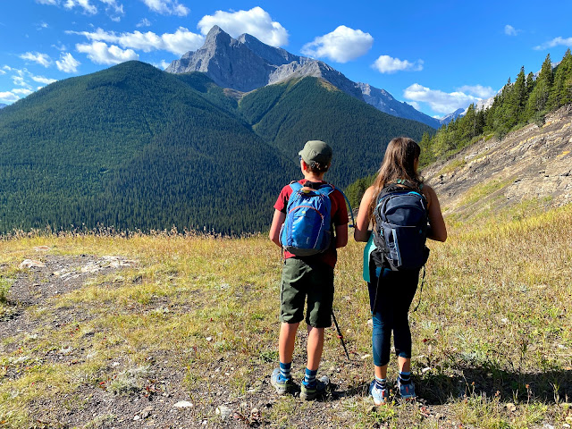
Centennial Ridge is the highest maintained trail ever built in the Canadian Rockies and is one of the best ridge walks in all of Kananaskis. Strong hikers can continue to the summit of Mount Allan which looms high above the Nakiska Ski Area. This is a very long day hike but it should go on every local hiker's "someday" list. Families will appreciate that there are few technical challenges and it's largely just a long scenic hike on a well built trail.

Hiking Centennial Ridge, the highest maintained trail in the Canadian Rockies

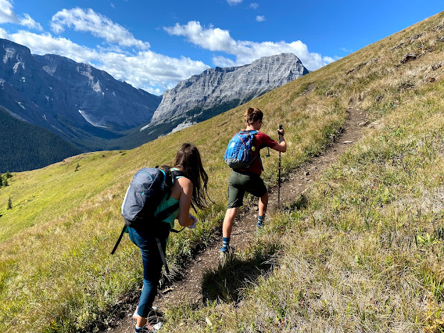
Hiking through the Rock Garden is a highlight on Centennial Ridge


Stats for the Hike 


Distance:  16 km round trip from Ribbon Creek to the summit of Mt. Allan according to my guide book. (I tracked 17 km.)

It's also possible to do a one-way traverse from Ribbon Creek to Dead Man's Flats but then you'd need two vehicles, you have an extra 2.5 km of hiking, and you also have an extra 200 metres of height loss at the end because Dead Man's Flats is lower than Ribbon Creek (so whatever you do, don't start at Dead Man's Flats!) 

All in all, it's just much easier to do the trip as an out and back hike starting and ending at Ribbon Creek.

Height gain: 1300 metres height gain from Ribbon Creek to the Mt. Allan summit. (I tracked 1400 metres including all ups and downs.)

Time it took us to complete the return hike: It took us just under 9 hours for this one (like I said, long day!) This was a solid moderate pace and we were faster than several adult groups on the trail so plan for 8+ hours depending on your personal pace.

Best time to do this hike: Wait until late June when the snow will be clear on the route. This is a beautiful summer hike when everything is very green and there are lots of marmots playing around in the rocks along the ridge.

Fall is another good time for this hike because there are larch trees along the ridge. The peak for golden larch hiking is the third weekend in September.

Annual Seasonal Closure: April 1 - June 21 for the protection of bighorn sheep during a sensitive birthing period

And don't forget to purchase your Kananaskis Conservation Pass!

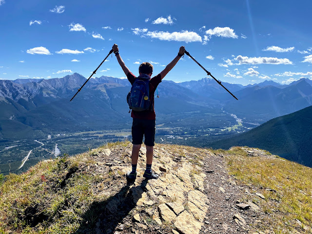
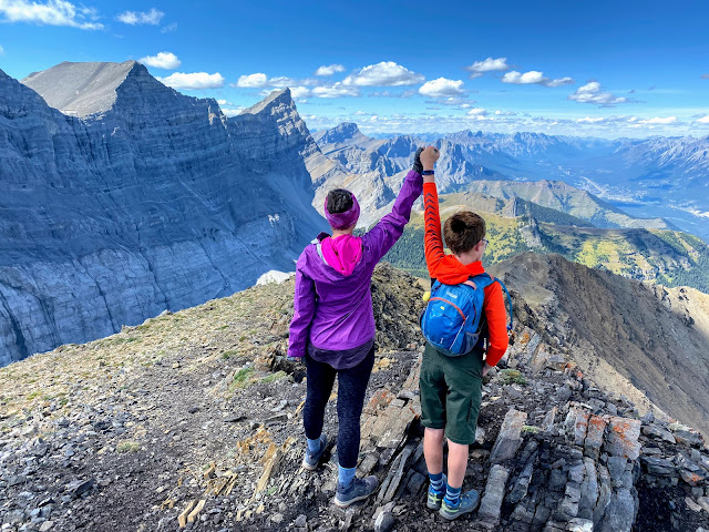
Mount Allan Summit looking over the Wind Valley


Rating: This is an easy scramble or an advanced hike. You won't have to use your hands at all on the trail to Olympic Summit. There is one small cliff band after that which requires some hands-on scrambling to reach the summit of Mt. Allan. 

There's a fairly decent trail the whole time and much of the trip is just steep hiking. Route finding is also generally easy once you get off the ski trails from Ribbon Creek.

And best of all, there is no bad scree on this hike nor is there any real exposure (other than the one small cliff band mentioned above.)


Recommended Guide Book: Kananaskis Country Trail Guide, Volume 1, Gillean Daffern - Amazon affiliate link


All Trails Link: Mount Allan from Centennial Ridge 

Note to download the map, you'll need to have a premium paid subscription. I find it to be worthwhile, even just so I can see how far I am from the summit every time somebody asks "how much further?" 

Having a downloaded map will also help you navigate through the ski trails down below.


Map of our Route: 


And should you want to navigate using my routes, you can follow me on All Trails.

You can also follow me on Strava

Looking down over the Nakiska Ski Area from Centennial Ridge

Ribbon Creek to the Centennial Ridge Trail

You'll park at the Ribbon Creek trailhead (google maps link) and start by hiking up the Hidden Trail, a wide cross-country ski trail. Within 300 metres there is a junction with the Coal Mine Trail where you turn left on another ski trail. Stay on this trail until you come to the official "Centennial Ridge Trail" sign and the trail becomes more narrow resembling an actual hiking trail.

That was your warm up. Now the climbing begins. The Coal Mine ski trail takes a more gradual approach but the Centennial Ridge trail climbs straight up between switchbacks on the Coal Mine Trail.

The first section of the hike is approximately 2.5 km in length and you'll climb a very gradual 250 metres of height until you cross the Coal Mine Ski Trail for the final time.

After this, it is straight UP until you reach the Olympic Summit.

The end of the ski trails at the Coal Mine site


Climbing to the top of the Olympic Summit (and the beginning of the ridge walk)

From the end of the Coal Mine Trail where you leave all ski trails long behind, it is a steep climb to your first summit (and you won't be alone if you decide that Olympic Summit is as far as you can make it.)

The trail to Olympic Summit is well maintained and easy to follow, but it is steep! There are many switchbacks (thank goodness) but you will be tired when you reach the top of the first summit.

The trail to Olympic Summit is relentlessly steep but well switchbacked

It is a 700 metre climb to the top of Olympic Summit overlooking the Nakiska Ski Area (plus the 250 metres you already climbed to get to the end of the ski trails.) This means you'll have already climbed 950 metres just to get to the top of Olympic Summit! And you still have 350 metres to go! - Like I said, it's a BIG day.

It's a gorgeous hike to Olympic Summit (even if you call it a day here!)

Distance to the top of the Olympic Summit is 3 km (So you'll climb 700 metres in 3 km.) And then add on the initial 2.5 km for 5.5 km of total distance just to reach the first summit of the day. - Good news, you only have 2.5 to 3 km left of hiking along Centennial Ridge to reach Mt. Allan.

Just a tad steep!

Climbing, climbing, climbing!

Simply put:

Ribbon Creek to the end of the ski trails and Coal Mine site: 2.5 km (250 metres climbing)

Coal Mine to Olympic Summit: 3 km (700 metres climbing)

Olympic Summit to Mt. Allan along Centennial Ridge: 2.5 to 3 km (350 metres climbing)

All numbers are approximate! Every guide book/website varies slightly from the All Trails app, and then my own personal stats were different yet.

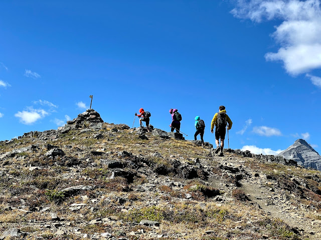
If you do nothing but Olympic Summit, it's still a rock star hike! 

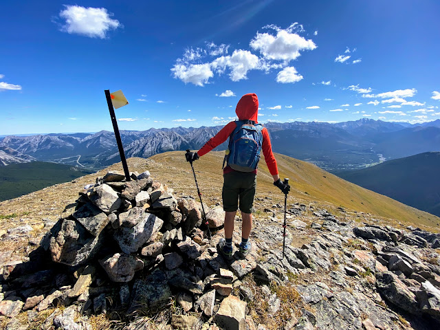
You'll know you've arrived when you reach a weather station and then a small cairn with a flag. This is your first summit and the Nakiska ski area is far below you now.

So far, you have climbed almost 1000 metres so be gracious with your bodies (and energy levels.) If you turn around here, it's still a fantastic hike!! (One of the best.) And Olympic Summit definitely counts as a mountain!

Reaching Olympic Summit above the Nakiska ski area

If only Nakiska ran chairlifts in the summer! 


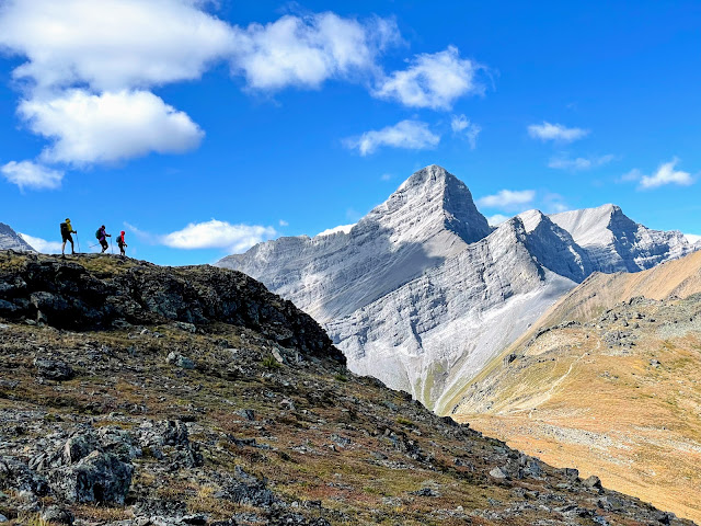
Hiking across Centennial Ridge to the Rock Garden 


The next 3 kilometres are the most spectacular part of the hike as you walk across Centennial Ridge. Most of the big height gain is done and while technically there is still 350 metres of climbing, it's spread over a long distance and you won't notice much of it until the final summit push.

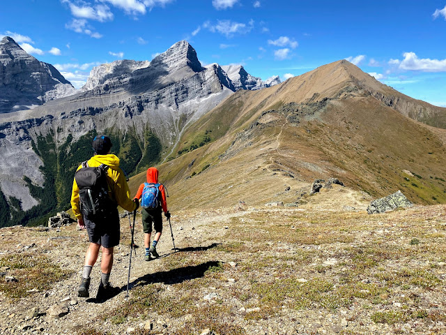
Easy hiking along Centennial Ridge,  the rock garden and the final summit of Mt. Allan ahead

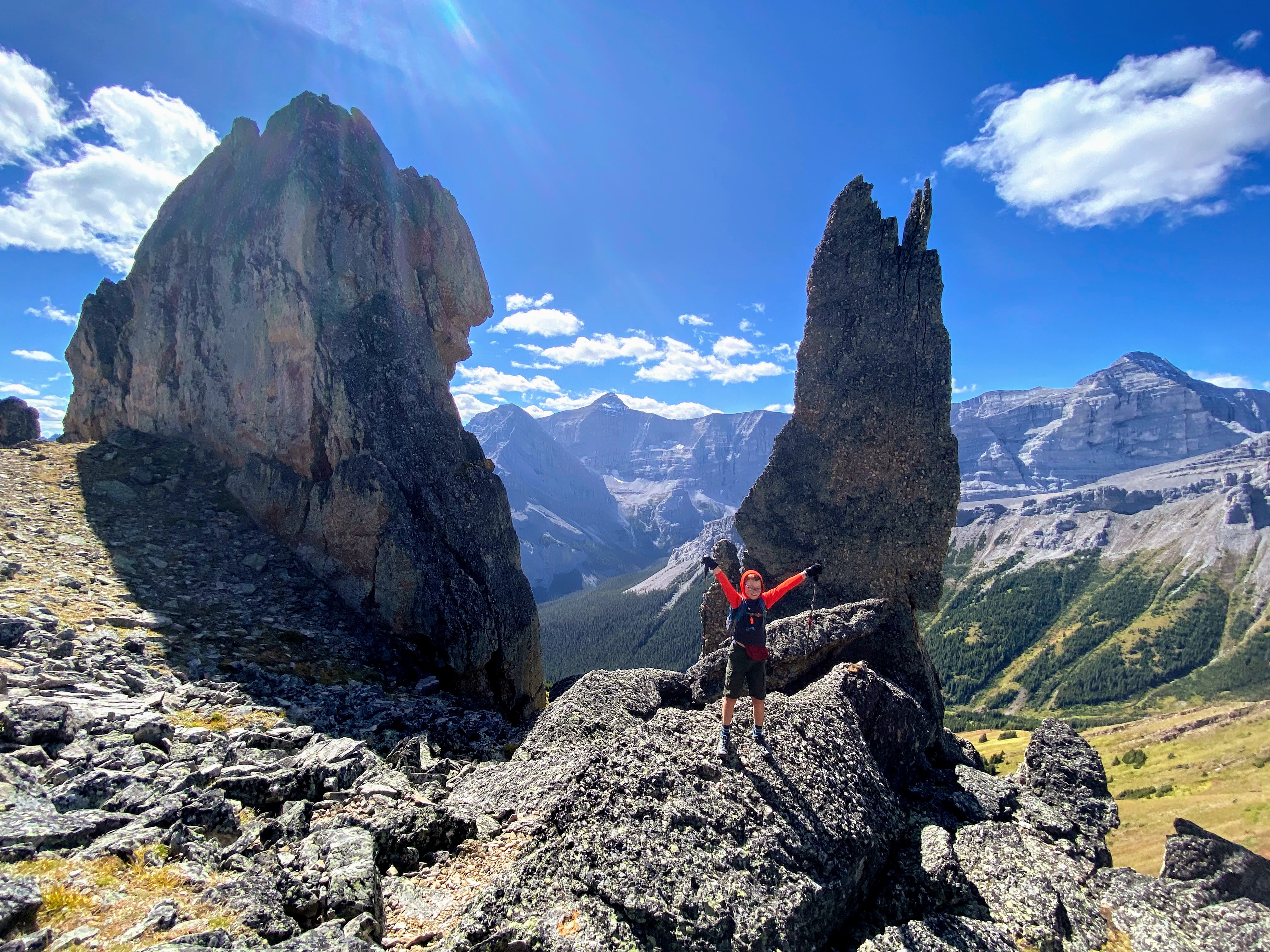
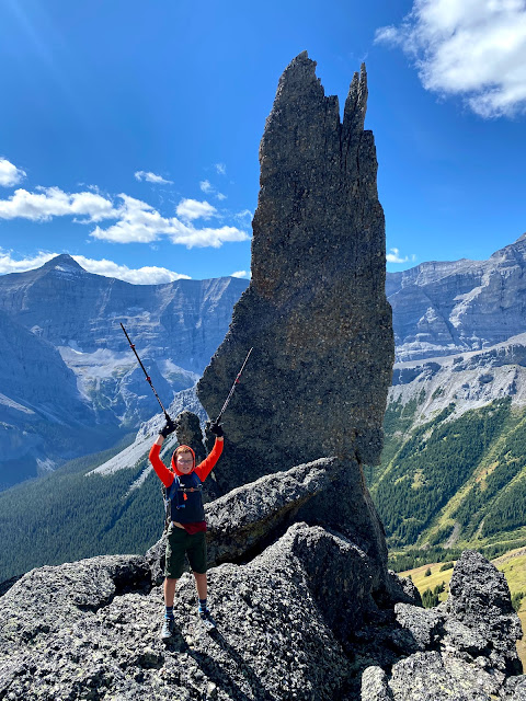
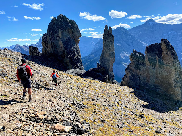
The big highlight along the ridge is the rock garden or the "mushroom garden" where you'll hike through giant conglomerate rock pillars, the largest named the "Claw." 

Striking a pose in the rock garden (watch for playful marmots here)
The giant "Claw!"
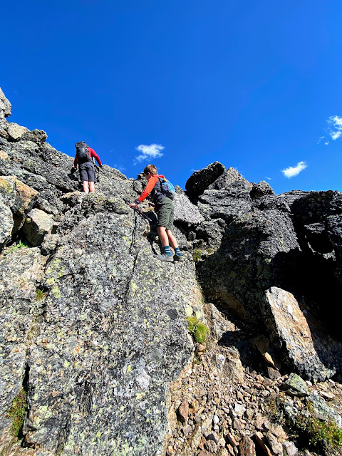
Beyond this, there is a short section that requires some brief down scrambling at a cliff band, but it's generally easy and there are lots of good hand holds. Remember, this is an official hiking trail.

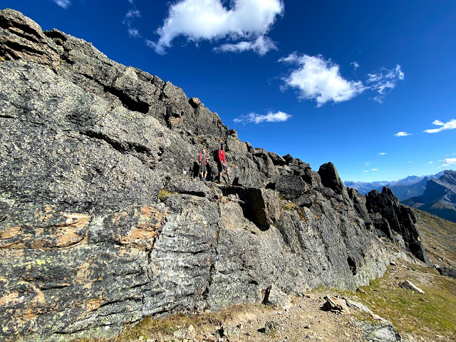
The short cliff band that you have to down climb to reach the summit

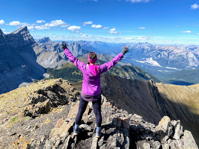
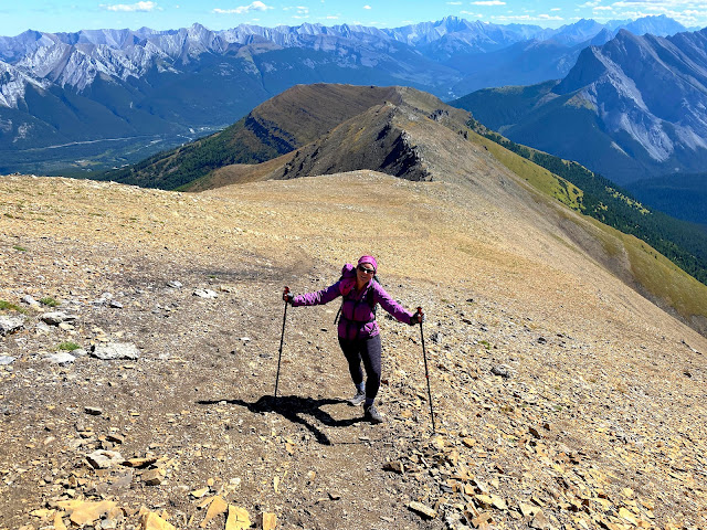
Hiking to the Summit of Mt. Allan 


Once you pass the down climb, it is a short but steep push to the summit. Fortunately the rock is solid and there is no bad scree.

Hiking to the summit of Mt. Allan (closer than it looks)
There's a good trail to the summit
The ridge is never overly airy or exposed and the summit should feel big enough for most people. Enjoy the views over the Kananaskis Valley and the Wind Valley, and then return the same way (unless you've set up a car shuttle for a one-way hike to Dead Man's Flats.)

Mt. Allan Summit 

On the Mt. Allan Summit looking down over the Wind Valley

The Return Hike to Ribbon Creek 


By now you're probably really tired so it's not comforting to know that you have an 8 km hike left to reach your vehicle!

Climbing back up the cliff band to the rock garden
My family passed the time with loud singing and trail games (partially because we'd seen a bear on the way up)  and I'm sure anybody who passed us would have thought we were completely crazy with some of our song choices ("I want to be sedated" by the Ramones was just one of the fun tunes we sang loudly off key running down the trail.)

Hiking back through the rock garden


Read about more great first summits in my complete guide below!